2007
TG3815 : St Benets abbey gatehouse - graffiti
taken 17 years ago, near to Upper Street, Norfolk, England
This is 1 of 3 images, with title starting with St Benets abbey gatehouse in this square
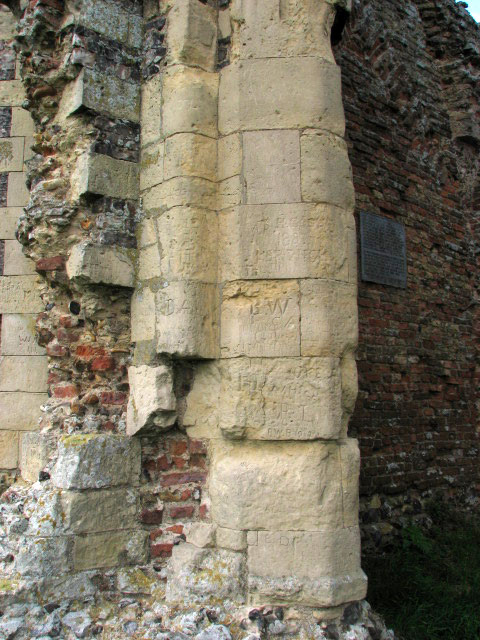
St Benets abbey gatehouse - graffiti
The Abbey of St Benets is situated on a sand and gravel island called Cow Holm, surrounded by grazing marshes beside the River Bure. In the Middle Ages the site was approached by land along a broad causeway from Horning to the north west and by river along the Bure, and there is no doubt that before the marshes were drained in the eighteenth century it was more often than not a true island. The abbey grounds comprised gardens and fish ponds, the outlines of which are still visible on the ground, between the abbey buildings and the gatehouse.
St Benets was the only Anglo-Saxon monastery in the county which continued in use throughout the Middle Ages, and moreover, the site was left undisturbed after the Dissolution because of its inaccessible location. When the surrounding marshes were drained in the early eighteenth century, the precinct ditch formed part of the drainage system and a mill was first erected at the eastern outflow to pump water into the river. No trace remains. Later in the same century the eastern drainage mill was replaced by the present one which was erected onto the front of the abbey's gatehouse > Link and the upper floor of the gatehouse was removed to provide room for the sails to turn. The medieval gatehouse and adjoining eighteenth-century windmill are well known and have become an icon for the county's historic landscape.
St Benets was the only Anglo-Saxon monastery in the county which continued in use throughout the Middle Ages, and moreover, the site was left undisturbed after the Dissolution because of its inaccessible location. When the surrounding marshes were drained in the early eighteenth century, the precinct ditch formed part of the drainage system and a mill was first erected at the eastern outflow to pump water into the river. No trace remains. Later in the same century the eastern drainage mill was replaced by the present one which was erected onto the front of the abbey's gatehouse > Link and the upper floor of the gatehouse was removed to provide room for the sails to turn. The medieval gatehouse and adjoining eighteenth-century windmill are well known and have become an icon for the county's historic landscape.
 Map © Crown Copyright")
TIP: Click the map for more Large scale mapping
- Grid Square
- TG3815, 99 images (more nearby 🔍)
- Photographer
- Evelyn Simak (more nearby)
- Date Taken
- Tuesday, 17 April, 2007 (more nearby)
- Submitted
- Wednesday, 2 March, 2011
- Subject Location
-
OSGB36:
 TG 380 157 [100m precision]
WGS84: 52:41.2309N 1:31.2383E - Camera Location
-
OSGB36: TG 380 157
- View Direction
- West-northwest (about 292 degrees)