2011
J1386 : Breakwater, Lough Neagh, Antrim
taken 13 years ago, near to Antrim, Northern Ireland
Breakwater, Lough Neagh, Antrim
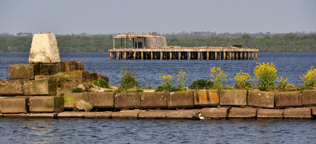
Wild mustard growing on the breakwater at the point where the Sixmilewater enters Lough Neagh previously seen, on a very windy day, in J1386 : The Sixmilewater at Antrim (4). The old torpedo platform J1286 : Platform, Lough Neagh is in the background.
The Sixmilewater, Co Antrim
The Sixmilewater is longer than the name suggests approximately 20 miles in total. It rises to the north of Carrickfergus and flows by way of Ballyclare, Dunadry and Antrim town into Lough Neagh.
Loading map... (JavaScript required)
- Grid Square
- J1386, 40 images (more nearby 🔍)
- Photographer
- Albert Bridge (more nearby)
- Date Taken
- Saturday, 30 April, 2011 (more nearby)
- Submitted
- Saturday, 30 April, 2011
- Subject Location
-
Irish:
 J 134 867 [100m precision]
WGS84: 54:42.9320N 6:14.4572W - Camera Location
-
Irish: J 134 866
- View Direction
- West-northwest (about 292 degrees)