2011
TG2721 : WWII site south of RAF Coltishall
taken 13 years ago, near to Great Hautbois, Norfolk, England
This is 1 of 11 images, with title WWII site south of RAF Coltishall in this square
WWII site south of RAF Coltishall
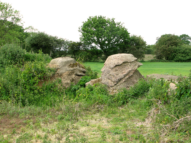
What at first glance looks like lumps of concrete appears to have been part of a fence because when viewed from top steel girders or posts can be seen embedded in the concrete. Or perhaps these are the stanchions of W/T masts which are reported to have stood here during the war.
The site comprises a number of buildings and structures and two pillboxes, one at each end. Known locally as the "old radio station", there were large masts secured by concrete stanchions and wooden accommodation huts encased within the brick walls, which would indicate a direction finding radar station serving RAF Coltishall.
The site comprises a number of buildings and structures and two pillboxes, one at each end. Known locally as the "old radio station", there were large masts secured by concrete stanchions and wooden accommodation huts encased within the brick walls, which would indicate a direction finding radar station serving RAF Coltishall.
RAF Coltishall
The station opened in 1939 as a fighter airfield during WW2. It later became a station for night fighters and then for ground attack aircraft until it was closed in 2006. Coltishall was the last surviving operational RAF airfield involved in the Battle of Britain other than RAF Northolt. The station was home to more than 80 fighter squadrons during its time of operation and 207 enemy aircraft were destroyed during the war. The airfield is currently owned by Norfolk County Council, with most of the former domestic site now being occupied by HMP Bure. See also: Link
 Map © Crown Copyright")
TIP: Click the map for more Large scale mapping
- Grid Square
- TG2721, 61 images (more nearby 🔍)
- Photographer
- Evelyn Simak (more nearby)
- Date Taken
- Sunday, 15 May, 2011 (more nearby)
- Submitted
- Monday, 16 May, 2011
- Subject Location
-
OSGB36:
 TG 273 212 [100m precision]
WGS84: 52:44.4561N 1:22.0202E - Camera Location
-
OSGB36: TG 274 212
- View Direction
- North-northwest (about 337 degrees)