2011
SZ0890 : Bournemouth: Red Arrows display on a tragic day
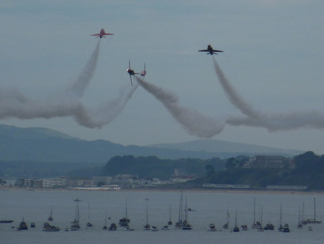
taken 13 years ago, near to Westbourne, Bournemouth, Christchurch & Poole, England
This is 1 of 503 images, with title starting with Bournemouth in this square
Bournemouth: Red Arrows display on a tragic day
Boats of onlookers form a rough square between Bournemouth and Boscombe piers as the Red Arrows perform one of their magnificent displays during the Bournemouth Air Show, a free four-day event which brings aircraft of all sorts as well as many associated stands and attractions on the ground.
The torrential rain and flash floods of Thursday, the opening day, were unfortunately not to be the worst story of this year's event. After completing this display, one of the Arrows, Red 4, crash landed less than a mile from Bournemouth Airport as it was preparing to land, and the pilot, Flight Lieutenant Jon Egging, was pronounced dead at the scene.
He can be proud of the part he played in these spectacles and condolences are extended to family and colleagues.
The BBC's news report on the incident is here: Link
In the distance, we see the cliffs of Poole Bay coming to an end at the Sandbanks peninsula, with some of the most expensive houses in the country towards the bottom left of the picture. Behind them, the dark, low clump is Brownsea Island in Poole Harbour, with the western Purbeck Hills in the background.
 Map © Crown Copyright")
TIP: Click the map for more Large scale mapping
- Grid Square
- SZ0890, 1540 images (more nearby 🔍)
- Photographer
- Chris Downer (more nearby)
- Date Taken
- Saturday, 20 August, 2011 (more nearby)
- Submitted
- Saturday, 20 August, 2011
- Subject Location
-
OSGB36:
 SZ 0893 9027 [10m precision]
WGS84: 50:42.7197N 1:52.4932W - Camera Location
-
OSGB36: SZ 1238 9131
- View Direction
- West-southwest (about 247 degrees)