TQ3870 : Green Chain Walk junction in Summerhouse Wood
taken 13 years ago, near to Beckenham, Bromley, England
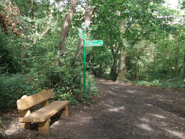
The path leads from Ravensbourne Railway Station (on Crab Hill) then it meets the Capital Ring (another long distance path) here. The Ring path leads straight on towards New Beckenham. It also leads right towards Downham.
At 96 hectares this is the largest open space in the Borough of Lewisham. The park contains a golf course and mixed woodland. The centre piece of the park is a grade II listed mansion. The Green Chain and Capital Ring walks pass through the park.
The Capital Ring is a surprisingly green route that encircles London. Distance is 78miles; it threads together parks and open spaces, mostly following pleasant residential roads in between. The route is an initiative of the London Walking Forum. The route is very well signed, with a Big Ben logo TQ1678 : Three walk logos, Gallows Bridge. The route is a walkers equivalent of the North and South Circular roads. Link

The Green Chain Walk is a network of paths in south-east London that connects locations including the Thames Barrier, Thamesmead and Erith along the river, and at the other end Crystal Palace and Chislehurst.
The route was created in 1977 by a joint team of four London boroughs. What makes it distinctive is the way it connects parks and other open spaces as far as possible, including fragments of ancient woodland at Oxleas and Lesnes Abbey Woods, heathland at Plumstead Common and large parks such as Avery Hill and Crystal Palace. The longest continuous route is Thamesmead to Crystal Palace (26.5km), with many links making up the total of 64km.
The official website is Link
 Map © Crown Copyright")
- Grid Square
- TQ3870, 181 images (more nearby 🔍)
- Photographer
- David Anstiss (more nearby)
- Date Taken
- Sunday, 18 September, 2011 (more nearby)
- Submitted
- Tuesday, 20 September, 2011
- Subject Location
-
OSGB36:
 TQ 3830 7057 [10m precision]
WGS84: 51:25.0370N 0:0.7517W - Camera Location
-
OSGB36: TQ 3831 7056
- View Direction
- North-northwest (about 337 degrees)