2011
TQ3079 : The Houses of Parliament
taken 13 years ago, near to City of Westminster, England
This is 1 of 14 images, with title The Houses of Parliament in this square
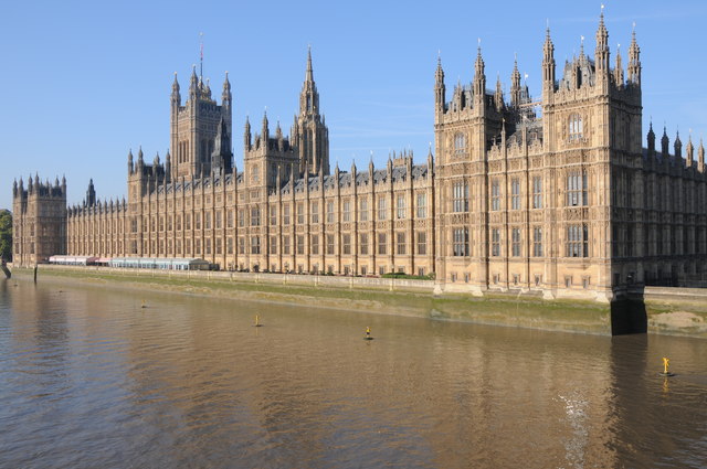
The Houses of Parliament
The Houses of Parliament viewed from Westminster Bridge. The present building was opened in 1867 and replaced the earlier Palace of Westminster when much of it was destroyed by fire in 1834. All that survived the fire was the remarkable Westminster Hall which dates from 1097 and was the setting for the trial of King Charles I. The architect of this building was Sir Charles Barry. The Duke of Wellington ordered that the new building should back onto the river so that it could not be surrounded by an angry mob. The building's river frontage is 940 ft (287m). The Victoria Tower can be seen in the background, it is 336 ft (101m) high. The flag pole is a further 50 ft (15m) high.
 Map © Crown Copyright")
TIP: Click the map for more Large scale mapping
- Grid Square
- TQ3079, 4108 images (more nearby 🔍)
- Photographer
- Philip Halling (more nearby)
- Date Taken
- Saturday, 1 October, 2011 (more nearby)
- Submitted
- Monday, 10 October, 2011
- Subject Location
-
OSGB36:
 TQ 3029 7948 [10m precision]
WGS84: 51:29.9551N 0:7.4622W - Camera Location
-
OSGB36: TQ 3047 7965
- View Direction
- Southwest (about 225 degrees)