TQ3961 : King Henry's Drive, Coal Tax Post
taken 13 years ago, near to New Addington, Croydon, England
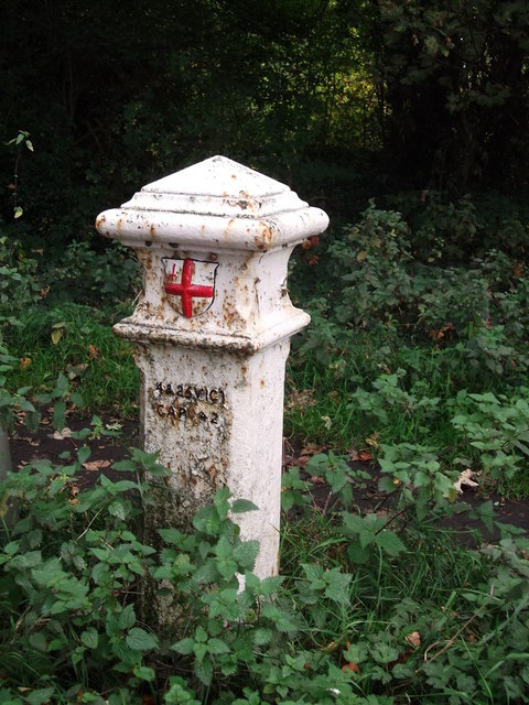
Coal Tax Posts were markers defining the area within which the Corporation of London could charge duty on coal entering the area. This area had been expanded in 1851 but then reduced in 1861 to coincide with the Metropolitan Police District of the day, the limits of which were between about 20 km and 30km from Charing Cross. It is from this latter time that most of the existing posts date. See Link
for further background, with much more comprehensive information at Martin Nail's excellent site, Link
Listed buildings and structures are officially designated as being of special architectural, historical or cultural significance. There are over half a million listed structures in the United Kingdom, covered by around 375,000 listings.
Listed status is more commonly associated with buildings or groups of buildings, however it can cover many other structures, including bridges, headstones, steps, ponds, monuments, walls, phone boxes, wrecks, parks, and heritage sites, and in more recent times a road crossing (Abbey Road) and graffiti art (Banksy 'Spy-booth') have been included.
In England and Wales there are three main listing designations;
Grade I (2.5%) - exceptional interest, sometimes considered to be internationally important.
Grade II* (5.5%) - particularly important buildings of more than special interest.
Grade II (92%) - nationally important and of special interest.
There are also locally listed structures (at the discretion of local authorities) using A, B and C designations.
In Scotland three classifications are also used but the criteria are different. There are around 47,500 Listed buildings.
Category A (8%)- generally equivalent to Grade I and II* in England and Wales
Category B (51%)- this appears generally to cover the ground of Grade II, recognising national importance.
Category C (41%)- buildings of local importance, probably with some overlap with English Grade II.
In Northern Ireland the criteria are similar to Scotland, but the classifications are:
Grade A (2.3%)
Grade B+ (4.7%)
Grade B (93%)
Read more at Wikipedia Link
 Map © Crown Copyright")
- Grid Square
- TQ3961, 55 images (more nearby 🔍)
- Photographer
- David Anstiss (more nearby)
- Date Taken
- Sunday, 9 October, 2011 (more nearby)
- Submitted
- Thursday, 13 October, 2011
- Subject Location
-
OSGB36:
 TQ 3948 6126 [10m precision]
WGS84: 51:20.0000N 0:0.0468E - Camera Location
-
OSGB36: TQ 3947 6127
- View Direction
- Southeast (about 135 degrees)