NS3985 : Boundary of Black Roundel
taken 12 years ago, 3 km from Gartocharn, West Dunbartonshire, Scotland
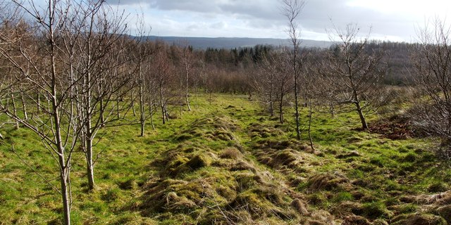
Between 1860 and 1898, a plantation called Black Roundel was created here on a large mound (of uncertain origins see Link
at WoSAS). By the 1950s, if not earlier, the plantation was gone. It had been encircled by a fence (now represented only by a low ridge) enclosing an area 240m long (N-S) by 60m wide (E-W). Black Roundel is in Whinny Hill Woodland: Link
A waymarked route, its outlying part in the form of a loop, has been created through this area of woodland. The spelling "Whinny Hill" is the one found on older maps, and it reflects the probable meaning, which is simply a hill covered in whin (gorse). Note, though, that the Woodland Trust (Scotland) tend to call it Whinney Hill; that form of the name also occurs on more recent mapping. Those looking for more information should therefore be aware of the alternative spelling.
 Map © Crown Copyright")
- Grid Square
- NS3985, 26 images (more nearby 🔍)
- Photographer
- Lairich Rig (more nearby)
- Date Taken
- Friday, 24 February, 2012 (more nearby)
- Submitted
- Thursday, 1 March, 2012
- Subject Location
-
OSGB36:
 NS 3997 8516 [10m precision]
WGS84: 56:1.9510N 4:34.1935W - Camera Location
-
OSGB36: NS 3996 8517
- View Direction
- Southeast (about 135 degrees)