SO7105 : WWII Pillbox on The Dumbles
taken 12 years ago, 3 km from Moorend, Gloucestershire, England
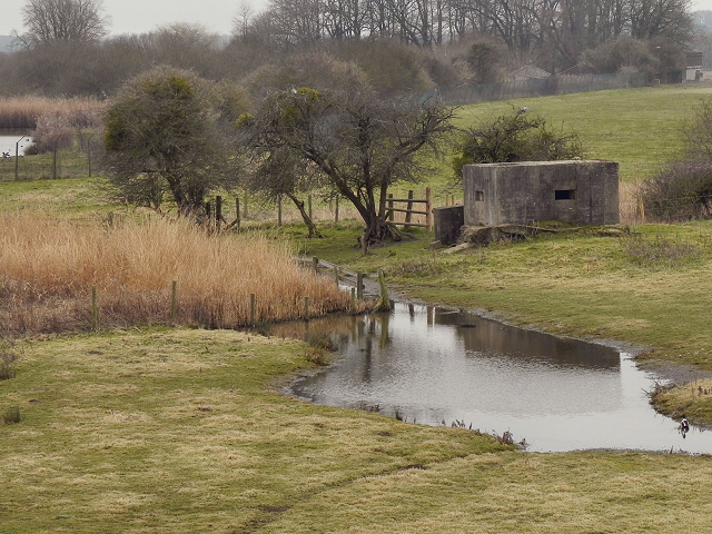
"Pillboxes" were military bunkers built during World War II in 1940 and into 1941. They were built in strategic places near Rivers, Railways and road junctions, creating a network of defences across Great Britain. 28,000 pill boxes were built, and about a fifth still survive. The construction was typically in concrete, sometimes with bricks externally which was used as shuttering during the construction. They came in different shapes and sizes; most common in hexagonal and octagonal shapes.
The largest number of pill boxes are found in the South-East of England closest to the threat of German invaders.
Pillbox study group Link
Defence of Britain Archive Link
Keywords: Pillbox, Pill Box, WWII
WWT Slimbridge is a reserve set up to care for and study wildfowl. It is managed by the Wildfowl and Wetlands Trust at Slimbridge, Gloucestershire, on the estuary of the river Severn. The reserve was the first WWT centre to be opened, on 10 November 1946, by artist and naturalist Sir Peter Scott.
The reserve site covers an area of 3 square kilometres, of which 500,000 square metres is landscaped and can be visited by the public. To cater for bird and duck watchers, several hides have been set up overlooking the fields, streams and lakes bordering the River Severn and the Gloucester and Sharpness Canal.
LinkWildfowl & Wetlands Trust Slimbridge
Link
 Map © Crown Copyright")
- Grid Square
- SO7105, 37 images (more nearby 🔍)
- Photographer
- David Dixon (more nearby)
- Date Taken
- Tuesday, 28 February, 2012 (more nearby)
- Submitted
- Monday, 5 March, 2012
- Subject Location
-
OSGB36:
 SO 7182 0501 [10m precision]
WGS84: 51:44.5846N 2:24.5725W - Camera Location
-
OSGB36: SO 7193 0504
- View Direction
- West-southwest (about 247 degrees)