2012
NZ2163 : Scotswood Delaval Drift, Scotswood Road
taken 15 years ago, near to Whickham, Gateshead, England
This is 1 of 2 images, with title starting with Scotswood Delaval Drift in this square
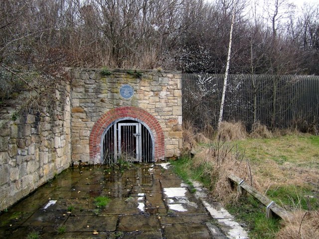
Scotswood Delaval Drift, Scotswood Road
The plaque above the gated entrance tells us that this was the drift entrance to the Scotswood Delaval mine. It was restored by Tyne & Wear County Council in 1986.
The drift was part of the Delaval Benwell Colliery (closed in 1901).
According to Link it may have been part of a railway incline from the Scotswood Delaval Drift which passes under the embankment of the former Scotswood, Newburn and Wylam Railway.
P L Younger 'Making Water' p.121-157 in J D Mather Ed. '200 years of British Hydrogeology', Geological Society Special Publication 225 (2004) describes its construction as early as 1670 to drain water from pits at West Kenton, Newbiggin and Whorlton down to the Tyne. He says it is no longer flowing, due to undermining and sustained pumping at Kibblesworth (Gateshead). This situation, however, changed radically quite recently (as can be seen by the water that now constantly flows out) and necessitated emergency remedial measures to prevent flooding the road.
To the west, at Bell's Close near the Scotswood Bridge, there was the exit of another tunnel, called Kitty's Drift. This carried an underground railway 3 miles from East Kenton Colliery down to the River Tyne, built around 1770. Its use for transporting coal was taken over by the Kenton and Coxlodge waggonway in 1808. Its exact course is now not known but historically notable as possibly the earliest underground railway in the world Link (Archive Link ) Link
Link (Archive Link )
To the left, six short rows of terraced houses used to run down to the road from the railway line: West St., Garden St., Delaval St., and Ida St. In the 1950s, the site to the right, bounded by the corrugated metal retaining wall, was occupied by the crane hire company, Reeds Cranes. They are now located, as Reed Bray Cranes Ltd., in Team Valley.
The drift was part of the Delaval Benwell Colliery (closed in 1901).
According to Link
it may have been part of a railway incline from the Scotswood Delaval Drift which passes under the embankment of the former Scotswood, Newburn and Wylam Railway.P L Younger 'Making Water' p.121-157 in J D Mather Ed. '200 years of British Hydrogeology', Geological Society Special Publication 225 (2004) describes its construction as early as 1670 to drain water from pits at West Kenton, Newbiggin and Whorlton down to the Tyne. He says it is no longer flowing, due to undermining and sustained pumping at Kibblesworth (Gateshead). This situation, however, changed radically quite recently (as can be seen by the water that now constantly flows out) and necessitated emergency remedial measures to prevent flooding the road.
To the west, at Bell's Close near the Scotswood Bridge, there was the exit of another tunnel, called Kitty's Drift. This carried an underground railway 3 miles from East Kenton Colliery down to the River Tyne, built around 1770. Its use for transporting coal was taken over by the Kenton and Coxlodge waggonway in 1808. Its exact course is now not known but historically notable as possibly the earliest underground railway in the world Link
(Archive Link ) LinkLink
(Archive Link ) To the left, six short rows of terraced houses used to run down to the road from the railway line: West St., Garden St., Delaval St., and Ida St. In the 1950s, the site to the right, bounded by the corrugated metal retaining wall, was occupied by the crane hire company, Reeds Cranes. They are now located, as Reed Bray Cranes Ltd., in Team Valley.


TIP: Click the map for more Large scale mapping
- Grid Square
- NZ2163, 54 images (more nearby 🔍)
- Photographer
- Andrew Curtis (more nearby)
- Date Taken
- Thursday, 8 March, 2012 (more nearby)
- Submitted
- Thursday, 8 March, 2012
- Subject Location
-
OSGB36:
 NZ 2105 6357
[10m precision]
WGS84: 54:57.9789N 1:40.3649W - Camera Location
-
OSGB36:
NZ 2104 6355
- View Direction
- North-northeast (about 22 degrees)


