TQ4279 : Footpath signpost, Royal Dockyard
taken 12 years ago, near to Woolwich Ferry, Greenwich, England
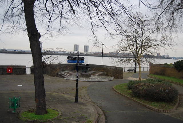
The Thames Cycle Route is part of the National Cycle Network. The Cycle Route stretches from Dartford up to Oxford along the banks of the River Thames.
This follows the majority of the Thames Path, but does divert in various sections. Especially where the Path follows a footpath only route. It also links National Cycle Route 1 (east of London) with National Cycle Route 4 (west of London).
This National Trail is 184 miles (294 km) long, following the River Thames from its source in the Cotswolds almost to the sea, finishing at the Thames Barrier in Greenwich.
The trail keeps to the banks of the river most of the route.
Website: Link
Woolwich Dockyard was a naval dockyard founded by King Henry VIII in 1512.
Like its counterpart Deptford Dockyard, it was probably chosen for its position - on the south bank of the tidal River Thames conveniently close to Henry's palace at Greenwich.
Its facilities ultimately included two large dry docks, a substantial basin (now used by local anglers), masting sheers, numerous storehouses, a gatehouse and clockhouse, gun bastions, and, in later years, a large metal-working factory used to produce anchors and other iron items used in shipbuilding.
As ships grew bigger and the Thames began to silt up, the dockyard eventually closed in 1869.
 Map © Crown Copyright")
- Grid Square
- TQ4279, 198 images (more nearby 🔍)
- Photographer
- N Chadwick (more nearby)
- Date Taken
- Friday, 17 February, 2012 (more nearby)
- Submitted
- Monday, 16 April, 2012
- Subject Location
-
OSGB36:
 TQ 4264 7927 [10m precision]
WGS84: 51:29.6631N 0:3.2009E - Camera Location
-
OSGB36: TQ 4263 7925
- View Direction
- North-northeast (about 22 degrees)