NS6266 : M8, Junction 13
taken 12 years ago, near to Royston, Glasgow, Scotland
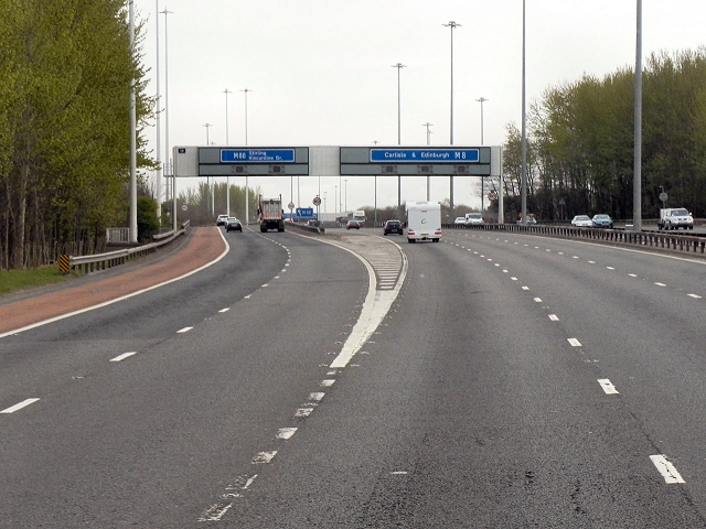
Note the typical Glasgow-type sign gantry with the following distinctive elements:
Near and offside support legs (basically 2 rectangular hollow sections with base plates to allow connections to the foundations)
A Main Frame (made up of rectangular hollow sections) - Over clad on the front and rear.
A Sub Frame (made up of smaller hollow sections and welded to main frame).
A Sign Face - acrylic sheets hung from the front of the sub frame over its full height.
Internal Electrics - sign lighting provided through the use of several dozen fluorescent battens.
Gantries of this type were first erected as part of the construction of the Kingston Bridge and its approach roads in 1970 and they are now a familiar sight on the network around Glasgow.
The M8 motorway is one of the most significant roads in Scotland. Running for approximately 61 miles in length, the M8 connects Scotlands two largest cities, Glasgow and Edinburgh, and serves other large communities including Airdrie, Coatbridge, Greenock, Livingston and Paisley. Of national economic importance, it provides a vital connection between the east and west of Scotland and, until the completion of the M74 in 2011, was the only motorway connection across the City of Glasgow.
The M8 is the busiest motorway in Scotland and one of the busiest in the United Kingdom; some sections of the route are used by up to 180,000 vehicles per day making it one of the most used motorways in Europe. It is notorious for traffic jams, especially its Central Glasgow section.
 Map © Crown Copyright")
- Grid Square
- NS6266, 53 images (more nearby 🔍)
- Photographer
- David Dixon (more nearby)
- Date Taken
- Friday, 20 April, 2012 (more nearby)
- Submitted
- Saturday, 5 May, 2012
- Subject Location
-
OSGB36:
 NS 621 662 [100m precision]
WGS84: 55:52.1630N 4:12.2352W - Camera Location
-
OSGB36: NS 621 661
- View Direction
- East-northeast (about 67 degrees)