2012
NS4879 : Burncrooks Reservoir: valve tower
taken 12 years ago, near to Burncrooks Reservoir [water Feature], West Dunbartonshire, Great Britain
This is 1 of 11 images, with title starting with Burncrooks Reservoir in this square
Burncrooks Reservoir: valve tower
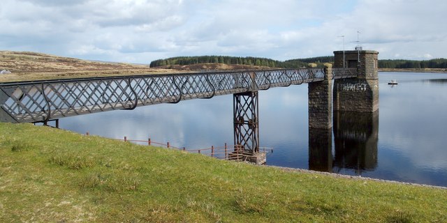
The valve tower, the stone structure at the end of the walkway, allows the flow of water from NS4879 : Burncrooks Reservoir to be controlled. The tower extends vertically below water level, right down to, and through, the embankment of the reservoir, to meet a horizontal tunnel, by means of which water leaves the reservoir. The vertical tower contains a shaft; sluice valves there, controlled from the top of the valve tower, adjust the outflow of water: NS4879 : Burncrooks Reservoir: outflow.
A small (though only compared to the valve tower) object can be seen out in the water, beyond the far end of the walkway; that device is shown, and its function explained, at NS4879 : Floating mixer on Burncrooks Reservoir.
A small (though only compared to the valve tower) object can be seen out in the water, beyond the far end of the walkway; that device is shown, and its function explained, at NS4879 : Floating mixer on Burncrooks Reservoir.
 Map © Crown Copyright")
TIP: Click the map for more Large scale mapping
- Grid Square
- NS4879, 38 images (more nearby 🔍)
- Photographer
- Lairich Rig (more nearby)
- Date Taken
- Friday, 27 April, 2012 (more nearby)
- Submitted
- Saturday, 12 May, 2012
- Subject Location
-
OSGB36:
 NS 4835 7937 [10m precision]
WGS84: 55:58.9962N 4:25.9363W - Camera Location
-
OSGB36: NS 4832 7939
- View Direction
- East-southeast (about 112 degrees)