NS8146 : Craignethan Castle - main entrance
taken 12 years ago, near to Crossford, South Lanarkshire, Scotland
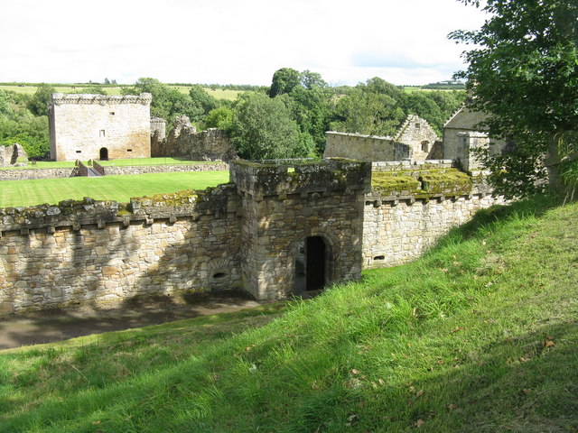
Described as the last of the great medieval Scottish Castles, its building by Sir James Hamilton of Finnart began about 1530. He was executed for treason in 1540, and the 2nd Earl of Arran succeeded him. The Hamiltons supported Mary Queen of Scots, and the castle was frequently under siege until 1579, when it fell to forces loyal to James VI; the Hamiltons were exiled and the castle abandoned. It was built on a rocky outcrop and protected on three sides by cliffs rising from the deep gorge of the River Nethan, a tributary of the River Clyde. It was, however, vulnerable to attack from higher land on the fourth side. So the original tower house and courtyard were protected by a massive ditch and rampart. An outer courtyard and west wall were added later, with a caponier in the ditch - a gun-emplacement that allowed attackers attempting to scale the main west rampart to be picked off. Because of defects they had a short life, and there are few in Britain the one at Craignethan is the best preserved. The southwest tower was incorporated into what is Andrew Hays House in 1665. It is now managed by Historic Scotland and well worth a visit, with plenty to explore. Link
Link
 Map © Crown Copyright")
- Grid Square
- NS8146, 89 images (more nearby 🔍)
- Photographer
- M J Richardson (more nearby)
- Date Taken
- Saturday, 28 July, 2012 (more nearby)
- Submitted
- Sunday, 29 July, 2012
- Subject Location
-
OSGB36:
 NS 8156 4633 [10m precision]
WGS84: 55:41.7553N 3:53.1553W - Camera Location
-
OSGB36: NS 8149 4637
- View Direction
- East-southeast (about 112 degrees)