2012
NS4480 : Possible remains of a structure
taken 12 years ago, near to Blairquhomrie, West Dunbartonshire, Scotland
This is 1 of 2 images, with title Possible remains of a structure in this square
Possible remains of a structure
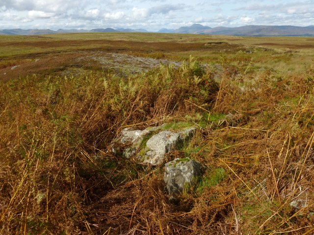
The area in the foreground was covered in bracken; I cleared away enough of it for the purpose of showing, in this picture, what may once have been the corner of a structure. From this possible corner, a wall-like feature, covered in turf, runs for several metres in a north-easterly direction (in this photograph, it runs diagonally upwards from this corner towards the right-hand edge of the photo). However, it is not worth trying to show such details photographically until the bracken has died back.
At this location, satellite imagery from 2005 see Link for details shows what appear to be the outlines of two roughly rectangular structures, both oriented NW-SE, one of them located in the angle formed by the junction of two burns, and the other just a few metres further to the south-east. The unusually low angle of the sun's illumination in that dataset brings out faint surface features particularly well; inspection on the ground can provide confirmation.
[As far as can be discerned from their appearance in the 2005 imagery, the two possible structures are centred on about NS4411380732 and NS4412480725, and measure about 7-8 metres (NW-SE) by about 5-6 metres. They are located on the north-eastern bank of the small burn that flows in a north-westerly direction to meet another burn.]
If these were indeed structures (in which case, this would be a new find), then the feature shown in the present photograph corresponds to the southern corner of the more south-easterly of the two.
Some old tracks (see the end-note) related to the local limestone-burning industry run past this spot. Given the satellite evidence for this particular spot, and the traces that are visible on the ground, it is possible that there were structures of some sort here: not necessarily buildings, but perhaps enclosures, or something else related to the above-mentioned limestone industry.
On the other hand, I have encountered limestone outcrops showing similar straight edges; and satellite imagery taken when the sun was particularly low can contain some misleading artefacts. I am therefore presenting the former presence of structures here as a possibility; others may later be able to confirm or disprove the idea.
[For what it's worth, I consider it more likely that this is NOT a structure. If in doubt, it's worth reporting something for others, with more knowledge or experience, to check; there's no shame in having a mistaken interpretation ruled out. For another site, elsewhere on the moor, that I do believe more likely to be traces of an artificial structures, see: NS4480 : Possible remains of a structure.]
Not far to the north, at Red Brae, are some clearly visible cultivation traces, and several other relics of the past: NS4481 : Cultivation traces at Red Brae, NS4481 : Remains of a field dyke, NS4481 : Remains of an enclosure, and NS4481 : Unfinished millstone at Red Brae.
Ben Lomond (NN3602) is visible right of centre in the background, providing a check on the view direction. Positioned centrally in this photo is an obvious dip in the skyline; that dip corresponds to the glen that leads to Loch Sloy (see, for example, NN2909 : Coiregrogain and NN2910 : Loch Sloy access road). Loch Lomond is situated between here and there, which is why the view to that glen is unobstructed by nearer hills or mountains.
Network of old limestone industry tracks :: NS4379
A very extensive network of ancient tracks on the moors in West Dunbartonshire links old quarries, ruined lime-kilns, and other sites connected with the local limestone-burning industry, which flourished in the 18th century. See Link for a Geograph article about the network, and Link
for an annotated satellite view of it.
 Map © Crown Copyright")
TIP: Click the map for more Large scale mapping
- Grid Square
- NS4480, 16 images (more nearby 🔍)
- Photographer
- Lairich Rig (more nearby)
- Date Taken
- Wednesday, 26 September, 2012 (more nearby)
- Submitted
- Saturday, 6 October, 2012
- Subject Location
-
OSGB36:
 NS 4414 8071 [10m precision]
WGS84: 55:59.6369N 4:30.0274W - Camera Location
-
OSGB36: NS 4414 8071
- View Direction
- North-northwest (about 337 degrees)