2012

NY5563 : Lanercost Priory Refectory Undercroft

taken 12 years ago, near to Lanercost, Cumbria, England
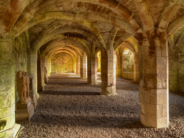
Lanercost Priory Refectory Undercroft
This vaulted undercroft of the south cloister range was originally divided into two. The far chamber, at the eastern end, was used for the storafe of food and drink whilst the western end contained the heating room where the canons were allowed the comfort of a hearth.
Lanercost Priory

Lanercost Priory was founded sometime between 1165 and 1174 by Henry II. It was built using stones from Hadrian's Wall, nearby. When completed in 1220, canons came from the priory in Norfolk, and remained for some 370 years until the Dissolution of the Monasteries in 1536, by Henry VIII.

After the Dissolution, the building passed to Thomas Dacre, who converted some of the buildings into private dwellings (now called the Dacre Hall). The north aisle of the Priory church continued in use as a parish church; it was reroofed and sympathetically restored in the nineteenth century and is still in use today.

The rest of the building fell into disrepair and, in 1929, the Priory ruins were put into public ownership, and today they are managed by English Heritage. There are the remains of the North and South Transepts, the Choir, the Sanctuary and the Cellarium

The remainder of the Priory, second only to Furness Abbey in interest as a ruin, is now in the hands of English Heritage.

LinkExternal link Lanercost Priory (English Heritage)
LinkExternal link Lanercost Priory Church (Visit Cumbria)
LinkExternal link Lanercost Priory (Wikipedia)


Creative Commons Licence [Some Rights Reserved]   © Copyright David Dixon and licensed for reuse under this Creative Commons Licence.
This photo is linked from: Automatic Clusters: · Refectory Undercroft [3] · Cloister Range [2] Other Photos: · Lanercost Priory from the South · Lanercost Priory - March 2016 (9) ·
1:50,000 Modern Day Landranger(TM) Map © Crown Copyright
+
1:50,000 Modern Day Landranger(TM) Map © Crown Copyright
TIP: Click the map for more Large scale mapping
Grid Square
NY5563, 269 images   (more nearby 🔍)
Photographer
David Dixon   (more nearby)
Date Taken
Monday, 15 October, 2012   (more nearby)
Submitted
Tuesday, 23 October, 2012
Subject Location
OSGB36: geotagged! NY 5559 6368 [10m precision]
WGS84: 54:57.9453N 2:41.7104W
Camera Location
OSGB36: geotagged! NY 5559 6368
View Direction
East-southeast (about 112 degrees)
Clickable map
+
NW N NE
W Go E
SW S SE
Image classification(about): Supplemental image
This page has been viewed about 196 times
You are not logged in login | register