2012
TF0920 : The funfair comes to town
taken 11 years ago, near to Bourne, Lincolnshire, England
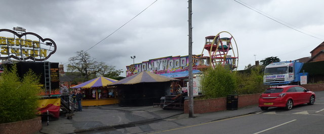
The funfair comes to town
Twice a year, as long as anyone can remember, Roger Tuby's funfair has come to Bourne. Once in the spring, on the way 'out' from winter quarters in Doncaster and once in the autumn, on the way 'back'. These days of simpler road transport mean that the steady progress of funfairs is not required, but they still stick to the traditional dates. At various times they have used Delaine's field (now built over) and the Well Head, but most visits are on the car park in Burghley street. There are always one or two hair-raisers for the teenagers, and gentle rides for the kiddies, along with dart-throwing or hoopla style stalls.
Tuby have a good general relationship with the town. This year's summer festival, mainly a matter of beer and rock music, would have had nothing for families had Tuby not brought half a dozen rides, through the rain and mud. And they were here for the BRM festival too. They have their own web site at Link with several pages of detailed family and fairground history and photographs.
Tuby have a good general relationship with the town. This year's summer festival, mainly a matter of beer and rock music, would have had nothing for families had Tuby not brought half a dozen rides, through the rain and mud. And they were here for the BRM festival too. They have their own web site at Link
 Map © Crown Copyright")
TIP: Click the map for more Large scale mapping
- Grid Square
- TF0920, 1678 images (more nearby 🔍)
- Photographer
- Bob Harvey (more nearby)
- Date Taken
- Friday, 26 October, 2012 (more nearby)
- Submitted
- Friday, 26 October, 2012
- Subject Location
-
OSGB36:
 TF 0940 2024 [10m precision]
WGS84: 52:46.1211N 0:22.7959W - Camera Location
-
OSGB36: TF 0942 2027
- View Direction
- South-southwest (about 202 degrees)