NS3879 : Memorial to Robert Ritchie
taken 11 years ago, near to Alexandria, West Dunbartonshire, Scotland
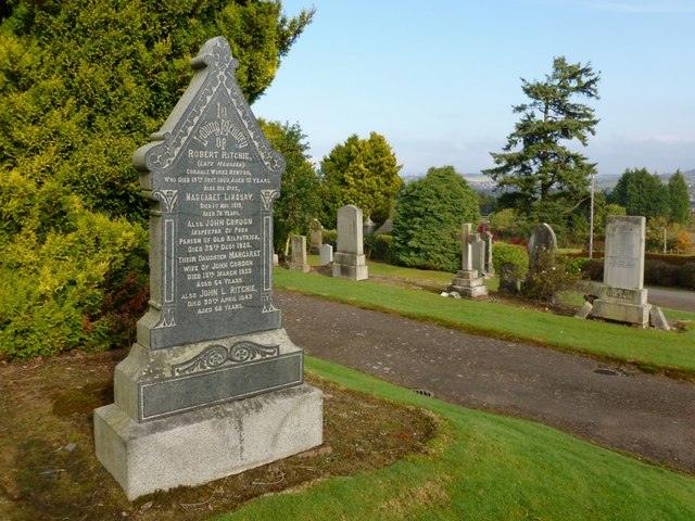
Robert Ritchie died in 1900. See NS3978 : Footpath leading around Cordale Point for the former site of the Cordale Works. A lade at Cordale Point is still known, by local anglers and by others familiar with the River Leven, as Ritchie's Lade; this is presumably a reference to the same family, and probably to Robert Ritchie himself. See NS3978 : Lade outflows at Cordale Point.
Local names that do not appear on any OS map are always worth recording.
This photograph is a view downhill across the terraces of the cemetery, in the direction of the former lodge at the main entrance.
The cemetery is located at the foot of the hills to the west of Alexandria, and the first interment took place here in August of 1881. The land for the cemetery had been purchased from P.B.Smollett of Bonhill (Patrick Boyle Smollett, second son of Admiral John Rouet Smollett). The cemetery was laid out in 1880 according to the plans of James Wilson of Greenock, and the work was carried out by Boyle and Tonner, contractors from Johnstone.
The lodge at the entrance of the cemetery was built by William Barlas of Alexandria, and the entrance gates themselves were made by Glasgow's Saracen Foundry [reference for all of the above information: Donald MacLeod's "Historic Families, Notable People, and Memorabilia of the Lennox" (1891)].
The entrance gates themselves, as well as some of the memorials in the cemetery, are category B listed. A listed building report provides further information: Link(at Historic Environment Scotland).
The cemetery, as originally laid out in 1880, was wholly located to the north of the burn, and provided 2831 lairs. When additional ground was purchased in 1898, this increased the number of lairs to 4895.
There have been several more extensions since then, which have added ground lying to the south of the burn (in fact, the greater part of the cemetery's area now lies to the south of the burn); the burn itself is crossed by two bridges within the cemetery.
 Map © Crown Copyright")
- Grid Square
- NS3879, 125 images (more nearby 🔍)
- Photographer
- Lairich Rig (more nearby)
- Date Taken
- Monday, 22 October, 2012 (more nearby)
- Submitted
- Thursday, 22 November, 2012
- Subject Location
-
OSGB36:
 NS 3852 7983 [10m precision]
WGS84: 55:59.0515N 4:35.3958W - Camera Location
-
OSGB36: NS 3852 7982
- View Direction
- Northeast (about 45 degrees)