2013
TQ6809 : Interior, St Oswald's church, Hooe
taken 11 years ago, near to Hooe, East Sussex, England
This is 1 of 2 images, with title Interior, St Oswald's church, Hooe in this square
Interior, St Oswald's church, Hooe
Grade I listed.
The church stands remote, although the village may have once stood here.
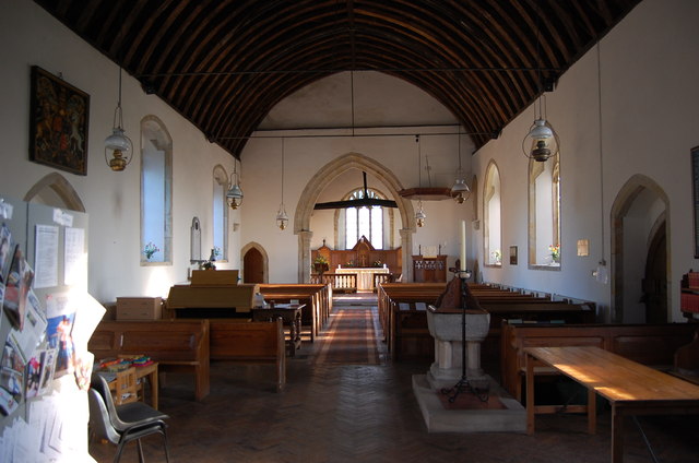
Most of the church dates from the 15th century although some walls may be earlier. It consists of a west tower, chancel and nave with no aisles. Like many churches, the chancel is inclined to the South by a few degrees. Sometimes known as a weeping chancel a reminder of the position of Christs head as he was dying on the cross.
The chancel roof is a cambered tie beam with a crown post. On the north wall of the sanctuary there are memorials to the Fuller family.
There is a 13th century North Chapel which was probably apsidal. It is now a vestry.
The west tower is 15th century with a narrow tower arch. The East end of the Chapel is rebuilt in brick, probably 17th century although the chimney could be later.
The font is a 12th century square marble bowl on a 19th-century pedestal.
Some of the windows have 15th century fragments. There are three piscinae throughout the church, there is also a stoup by the South door.
Some of the South Windows still have their 15th century label stops with carved heads. There is also a priests door.
Restoration was carried out in the late 19th century, there were further repairs in 1959 and 1978.
See other images of St Oswald's church, Hooe
The church stands remote, although the village may have once stood here.
Most of the church dates from the 15th century although some walls may be earlier. It consists of a west tower, chancel and nave with no aisles. Like many churches, the chancel is inclined to the South by a few degrees. Sometimes known as a weeping chancel a reminder of the position of Christs head as he was dying on the cross.
The chancel roof is a cambered tie beam with a crown post. On the north wall of the sanctuary there are memorials to the Fuller family.
There is a 13th century North Chapel which was probably apsidal. It is now a vestry.
The west tower is 15th century with a narrow tower arch. The East end of the Chapel is rebuilt in brick, probably 17th century although the chimney could be later.
The font is a 12th century square marble bowl on a 19th-century pedestal.
Some of the windows have 15th century fragments. There are three piscinae throughout the church, there is also a stoup by the South door.
Some of the South Windows still have their 15th century label stops with carved heads. There is also a priests door.
Restoration was carried out in the late 19th century, there were further repairs in 1959 and 1978.
See other images of St Oswald's church, Hooe
 Map © Crown Copyright")
TIP: Click the map for more Large scale mapping
- Grid Square
- TQ6809, 90 images (more nearby 🔍)
- Photographer
- Julian P Guffogg (more nearby)
- Date Taken
- Thursday, 17 January, 2013 (more nearby)
- Submitted
- Thursday, 17 January, 2013
- Subject Location
-
OSGB36:
 TQ 6828 0917 [10m precision]
WGS84: 50:51.4537N 0:23.3747E - Camera Location
-
OSGB36: TQ 6827 0917
- View Direction
- East-northeast (about 67 degrees)