NS3478 : St Mahew's Chapel
taken 11 years ago, near to Geilston, Argyll And Bute, Scotland
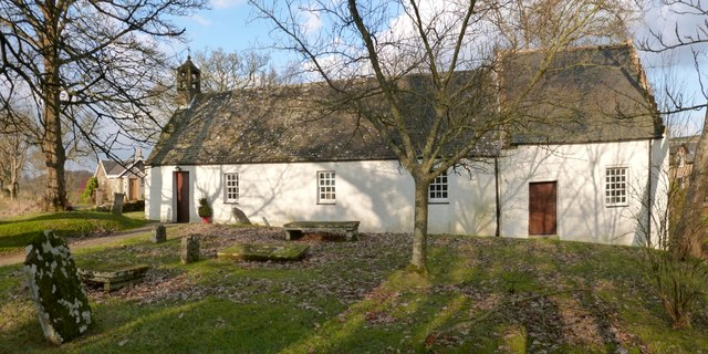
The present picture also shows the old burial ground beside the chapel; long ago, it was the destination of a coffin road called the Stoneymollan Road.
The building in the left background is East Lodge, which stands at the start of a farm track leading to Drumhead. The upright stone visible in front of the lodge is the one that appears in the foreground of another picture of the NS3478 : Burial ground at St Mahew's Chapel.
This building is a restoration (carried out from 1950-53, following historical research) of one that was dedicated in 1467. However, there is known to have been a chapel here in the fourteenth century. There may have been a religious building on this site from the early sixth century onwards. See Link
(at Canmore) for more information on the building, and for details of an incised cross-slab kept within it.
This route from Balloch to the clachan of Kirkton was an old coffin road (see Link
 Map © Crown Copyright")
- Grid Square
- NS3478, 122 images (more nearby 🔍)
- Photographer
- Lairich Rig (more nearby)
- Date Taken
- Friday, 18 January, 2013 (more nearby)
- Submitted
- Monday, 4 February, 2013
- Subject Location
-
OSGB36:
 NS 3420 7863 [10m precision]
WGS84: 55:58.3169N 4:39.5012W - Camera Location
-
OSGB36: NS 3420 7860
- View Direction
- NORTH (about 0 degrees)