2013
TF0659 : St Oswald's church, Blankney
taken 11 years ago, near to Blankney, Lincolnshire, England
This is 1 of 2 images, with title St Oswald's church, Blankney in this square
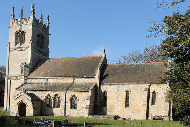
St Oswald's church, Blankney
Grade II*listed
The village of Blankney predates the Norman Conquest, and is mentioned in the Domesday Book. There was probably an Anglo-Saxon church before the present one.
The church dates from the 12th century onwards. The tower was rebuilt in 1805, and the church restored in 1880.
It consists of a west tower, nave and aisles, a chancel with a north chantry chapel and a south porch.
The tower is of three stages with clasping buttresses and is topped by crocketted pinnacles. The south face has an octagonal stair turret. The tower has gargoyles at each corner, and there are eight bells.
The nave has a three Bay arcade with octagonal piers and stone seats around the bases. The tower arch is 19th-century, the chancel arch is similar to the arches and a Chantry Chapel, all with octagonal piers. The north aisle arch also has dogtooth decoration.
There is a heavily restored double sedilia. The wooden roofs, pulpit, choir stalls and pews are 19th century and there is a wooden reredos from circa 1900 which is painted and gilded.
There is a white marble monument to Lady Florence Chaplin who died in 1881 by Sir Edgar Boehm. The Chaplins were the owners of Blankney Hall which was built in the 1820s. The Hall caught fire in 1945 and was never rebuilt.
See other images of St Oswald's church, Blankney
 Map © Crown Copyright")
TIP: Click the map for more Large scale mapping
- Grid Square
- TF0659, 27 images (more nearby 🔍)
- Photographer
- J.Hannan-Briggs (more nearby)
- Contributed by
- Julian P Guffogg (more nearby)
- Date Taken
- Saturday, 2 March, 2013 (more nearby)
- Submitted
- Monday, 11 March, 2013
- Subject Location
-
OSGB36:
 TF 0682 5999 [10m precision]
WGS84: 53:7.5831N 0:24.3043W - Camera Location
-
OSGB36: TF 0682 5997
- View Direction
- NORTH (about 0 degrees)