2013
SJ8398 : Manchester Cathedral Visitor Centre
taken 11 years ago, near to Manchester, England
This is 1 of 119 images, with title starting with Manchester Cathedral in this square
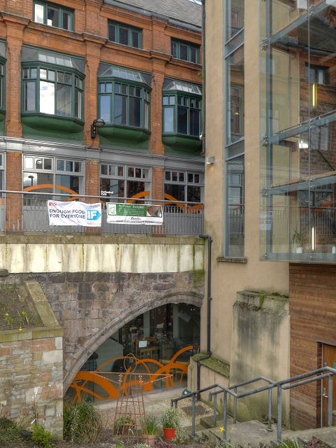
Manchester Cathedral Visitor Centre
As part of the Millennium Quarter redevelopment the Cathedral used a narrow office building called Hanging Bridge Chambers to create a Visitors' Centre. The interesting part is the arch in the basement which can be seen in the photograph.
This arch is part of northern arch of Hanging Bridge (SJ8398 : Hanging Bridge), a mediæval bridge over a stream known as Hanging Ditch which ran from the River Irk to the River Irwell. The stream became badly polluted and in 1600 the Hanging Ditch was condemned as an unsanitary open sewer, and in the following years the ditch was culverted and the bridge buried and built over. The bridge was largely forgotten (although the area retained the name "Hanging Ditch") until uncovered during demolition work in the 1880s. Covered up during the Victorian expansion of Manchester, the bridge remained hidden until, more than 100 years later it was uncovered again, and following restoration work it went on display in 2002 as a part of Manchester Cathedral's newly built visitor centre.
From outside, the bridge is now largely hidden by modern buildings, but it can be seen from inside the basement of the Cathedral Visitor Centre, where it forms one side of the refectory. The bridge is listed as a Scheduled Ancient Monument.
Link BBC News December 2001
This arch is part of northern arch of Hanging Bridge (SJ8398 : Hanging Bridge), a mediæval bridge over a stream known as Hanging Ditch which ran from the River Irk to the River Irwell. The stream became badly polluted and in 1600 the Hanging Ditch was condemned as an unsanitary open sewer, and in the following years the ditch was culverted and the bridge buried and built over. The bridge was largely forgotten (although the area retained the name "Hanging Ditch") until uncovered during demolition work in the 1880s. Covered up during the Victorian expansion of Manchester, the bridge remained hidden until, more than 100 years later it was uncovered again, and following restoration work it went on display in 2002 as a part of Manchester Cathedral's newly built visitor centre.
From outside, the bridge is now largely hidden by modern buildings, but it can be seen from inside the basement of the Cathedral Visitor Centre, where it forms one side of the refectory. The bridge is listed as a Scheduled Ancient Monument.
Link
 Map © Crown Copyright")
TIP: Click the map for more Large scale mapping
- Grid Square
- SJ8398, 3265 images (more nearby 🔍)
- Photographer
- David Dixon (more nearby)
- Date Taken
- Thursday, 28 March, 2013 (more nearby)
- Submitted
- Thursday, 28 March, 2013
- Subject Location
-
OSGB36:
 SJ 8385 9869 [10m precision]
WGS84: 53:29.0805N 2:14.6906W - Camera Location
-
OSGB36: SJ 8383 9871
- View Direction
- Southeast (about 135 degrees)