SJ5686 : Lock and Bridge, Fiddler's Ferry
taken 11 years ago, near to Penketh, Warrington, England
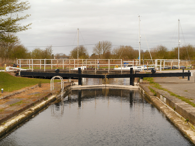
Between 1762 and 1833, this was the end of the Sankey Canal, where boats joined or left the tidal River Mersey. A second lock, now filled in, was built a short distance to the west, to enable more boats to lock through with each tide. The locks became disused after the canal was extended to Widnes in 1833. This lock was restored in the 1980s by Warrington Council and now gives access to the marina.
First opened in 1757, the Sankey Canal (which is also known as the Sankey Brook Navigation and the St Helens Canal) runs for about 15 miles along the valley of the Sankey Brook from the point where the brook joined the River Mersey, to a location to the north east of St Helens, with short branches to Blackbrook and Gerrard's Bridge. Only two short sections at Widnes and Fiddler's Ferry are open for navigation. Much of the canal is in water although some sections have been infilled.
Built primarily to take coal down to the Mersey and Liverpool, the final traffic on The Sankey was very different, and in the opposite direction; raw sugar for the Sankey Sugar Works at Earlestown, from Liverpool. The ending of the sugar traffic in 1959 led to the closure of the Canal in 1963 after which, the canal was left neglected. It was dirty and ran through an area of chemical works and other industries.
in 1985, The Sankey Canal Restoration Society (SCARS) was formed with the help and encouragement of the St. Helens Groundwork Trust. The principal aim of the Society is to achieve the full restoration of the Canal (LinkSCARS website).
 Map © Crown Copyright")
- Grid Square
- SJ5686, 85 images (more nearby 🔍)
- Photographer
- David Dixon (more nearby)
- Date Taken
- Tuesday, 23 April, 2013 (more nearby)
- Submitted
- Thursday, 25 April, 2013
- Subject Location
-
OSGB36:
 SJ 5610 8649 [10m precision]
WGS84: 53:22.4060N 2:39.6781W - Camera Location
-
OSGB36: SJ 5611 8647
- View Direction
- North-northwest (about 337 degrees)