NS6065 : Fundamental Bench Mark, Glasgow
taken 11 years ago, near to Royston, Glasgow, Scotland
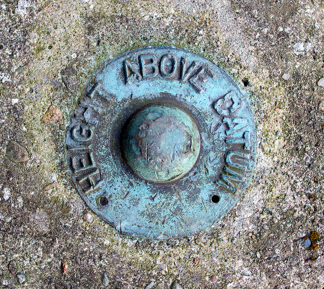
Necropolis Fundamental Bench Mark is outside the east wall of Glasgow Necropolis and is easily accessed from Firpark Street. The following information is taken from the Bench Mark Database at Link
:
"This fundamental bench mark was used during the Second geodetic levelling, Scotland (1936-52), and was levelled with a height of 166.1846 feet [50.6531 metres] above mean sea level (Newlyn datum). It was included on the Dunlop to Milngavie, Milngavie to Necropolis and Necropolis to Dunlop levelling lines. [It was also] used during the Third geodetic levelling, Scotland (1956-68), and was levelled with a height of 166.1846 feet [50.6531 metres] above mean sea level (Newlyn datum). It was included on the Milngavie to Bowling (via Govan) and Necropolis to Dunlop levelling lines. The bolt was found to be damaged in 1959 and a new one was inserted; it was reheighted 1962 as 166.2131 ft. (50.6618m) above Newlyn Datum."
The mark is now part of the Ordnance Survey Passive GPS Network and is known as "Necropolis FBM H1NS6065" Link
It is is fairly good condition but has been chipped at the top.
Bench marks Link
- Fundamental bench marks have been constructed at selected sites where foundations can be set on stable strata such as bedrock. Each FBM consists of a buried chamber with a brass bolt set in the top of a granite pillar. See NG8825 : Dornie fundamental bench mark for an example. FBMs were used in Ireland as well as GB but those in Ireland do not have any surface markers, nor are they marked on standard maps.
- Flush brackets consist of metal plates about 90 mm wide and 175 mm long. Each bracket has a unique serial number. They are most commonly found on most Triangulation Pillars, some churches or on other important civic buildings. See J3270 : Flush Bracket, Belfast for an example.
- Cut bench marks are the commonest form of mark. They consist of a horizontal bar cut into a wall or brickwork and are found just about anywhere. A broad arrow is cut immediately below the centre of the horizontal bar. See J3372 : Bench Mark, Belfast for an example. The horizontal mark may be replaced by or contain a bolt - see J1486 : Bench Mark, Antrim.
Other marks include:
- Projecting bench marks such as SD8072 : Projecting Bracket Benchmark on St Oswald's Tower
- Bolt bench marks such as SJ1888 : OSBM bolt on Hilbre Island
- Rivet bench marks such as J3978 : Bench Mark, Holywood
- Pivot bench marks such as SJ2661 : Pivot bench mark on Leeswood Bridge
Bench marks are commonly found on older buildings or other semi-permanent features such as stone bridges or walls. Due to updated mapping techniques and technological advances such as GPS, bench marks are no longer maintained. Many are still in existence and the markers will probably remain until they are eventually destroyed by redevelopment or erosion.
 Map © Crown Copyright")
- Grid Square
- NS6065, 643 images (more nearby 🔍)
- Photographer
- Rossographer (more nearby)
- Date Taken
- Saturday, 27 April, 2013 (more nearby)
- Submitted
- Tuesday, 30 April, 2013
- Subject Location
-
OSGB36:
 NS 6064 6551 [10m precision]
WGS84: 55:51.7538N 4:13.6983W - Camera Location
-
OSGB36: NS 6064 6551
- View Direction
- Northwest (about 315 degrees)