NT5734 : Leaderfoot Viaduct
taken 11 years ago, near to Newstead, Scottish Borders, Scotland
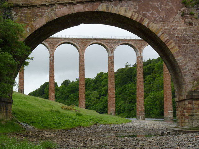
This handsome and slender structure was built in 1865 for the Berwickshire Railway, which became part of the North British Railway and then the London and North Eastern Railway.
Passengers services ran on the line until August 1948 when they were suspended following damage caused by the catastrophic flooding in the area. Although passenger service resumed over the eastern section of the line, only freight traffic remained until final closure in 1965.
The viaduct comprises 19 arches, each with a span of 13 metres, and the highest of which rises 37 metres above the River Tweed. Some of the southern piers have at some stage been strengthened with straps and buttresses. It is surprising that relatively short piers are involved, not the tallest ones.
Unlike many disused railway structures, it is no longer railway property, having passed into the hands of Historic Scotland who were responsible for its restoration in 1992-95.The viaduct was Listed Category B in 1971, but upgraded to Category A in 1986.
Built by Alexander Stevens between 1776 and 1780 to replace a ferry. The main span of 31 metres was exceptional for this date, and the arch ring itself is only about 75 cm thick at the crown. The sloping string course suggests that at some stage the bridge has been added to create a level roadway. Listed Category A.
 Map © Crown Copyright")
- Grid Square
- NT5734, 213 images (more nearby 🔍)
- Photographer
- Alan Murray-Rust (more nearby)
- Date Taken
- Wednesday, 12 June, 2013 (more nearby)
- Submitted
- Friday, 14 June, 2013
- Subject Location
-
OSGB36:
 NT 573 347 [100m precision]
WGS84: 55:36.2582N 2:40.6905W - Camera Location
-
OSGB36: NT 575 346
- View Direction
- West-northwest (about 292 degrees)