2013
NT2673 : Canongate Tolbooth
taken 11 years ago, near to Edinburgh, Scotland
This is 1 of 7 images, with title Canongate Tolbooth in this square
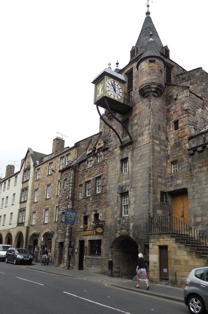
Canongate Tolbooth
The Tolbooth was built in 1591, it was here that the tolls or public dues were collected.
It also served as the council house, courtroom and prison for the Canongate. Although most of the prisoners were transferred to a newly built jail on Calton Hill.
The large clock face is dated 1820 and replaced an earlier clock from the 17th Century.
The Latin inscription on the front of the building reads:
The place of the seal of the Burgh.
For one's country and one's successors, 1591.
Link (Archive Link )
It also served as the council house, courtroom and prison for the Canongate. Although most of the prisoners were transferred to a newly built jail on Calton Hill.
The large clock face is dated 1820 and replaced an earlier clock from the 17th Century.
The Latin inscription on the front of the building reads:
The place of the seal of the Burgh.
For one's country and one's successors, 1591.
Link
The Royal Mile
The Royal Mile is 1 Scottish Mile long (1.1 imperial miles). It is a number of streets that lead down from Edinburgh Castle to Holyrood Palace. The royal mile is the heart of Edinburgh Old Town and contains many of the city's important buildings. The mile follows the "tail" of the Edinburgh Crag and tail a feature created by glacial erosion.
Wikipedia: Link
 Map © Crown Copyright")
TIP: Click the map for more Large scale mapping
- Grid Square
- NT2673, 2367 images (more nearby 🔍)
- Photographer
- Paul Gillett (more nearby)
- Date Taken
- Sunday, 9 June, 2013 (more nearby)
- Submitted
- Friday, 14 June, 2013
- Subject Location
-
OSGB36:
 NT 26431 73758 [1m precision]
WGS84: 55:57.0718N 3:10.7812W - Camera Location
-
OSGB36: NT 26436 73753
- View Direction
- Northwest (about 315 degrees)