TQ7035 : Pulpit, Christchurch, Kilndown
taken 11 years ago, near to Kilndown, Kent, England
Grade I listed
The church was commissioned by Field Marshal Viscount Beresford and built between 1839 and 1841, the architect was Anthony Salvin. It was embellished and altered by Alexander Roos between 1814 1845.
The church is built from sandstone with slate roof. There is a chancel, nave and west tower which has a broach spire with lucarnes.
The church was commissioned with a hammerbeam roof which was altered by Beresford's stepson, Alexander James Beresford Hope. The hammerbeam ends in the chancel have carved angels.
The chancel is separated from the nave by a wooden screen designed by R. C. Carpenter which is painted and heavily decorated.
There is a stone altar, piscina and sedilia, and a richly decorated door to the vestry.
The reredos dates from 1869 featuring the crucifixion. There are stalls with poppy heads, figures and carved panels of stages of the cross.
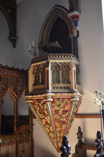
The pulpit is entered from the vestry projecting from the wall at a higher level.
The organ was installed in 1840 and moved to its present position in 1860. It was enlarged in 1911.
The rear of the church features a series of marquetry panels, known as the Bedgebury panels. They were produced between 1865 and 1881 and consist of a series of roundels featuring the Saints and biblical characters. They were produced in the workshops at Bedgebury Park, the wood being from the Bedgebury estate.
 Map © Crown Copyright")
- Grid Square
- TQ7035, 106 images (more nearby 🔍)
- Photographer
- Julian P Guffogg (more nearby)
- Date Taken
- Sunday, 30 June, 2013 (more nearby)
- Submitted
- Sunday, 30 June, 2013
- Subject Location
-
OSGB36:
 TQ 7006 3518 [10m precision]
WGS84: 51:5.4433N 0:25.6200E - Camera Location
-
OSGB36: TQ 7006 3518
- View Direction
- South-southwest (about 202 degrees)