2007
SD7916 : Ramsbottom Level Crossing 2007
taken 17 years ago, near to Ramsbottom, Bury, England
This is 1 of 8 images, with title starting with Ramsbottom Level Crossing in this square
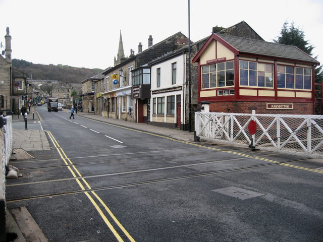
Ramsbottom Level Crossing 2007
It used to be a rough ride but now after a long overdue refurbishment it has a brand new smooth road surface ,laid over the last couple of weekends, the level crossing at Ramsbottom is a credit to Bury Council and the East Lancs Railway Archive Link
The Bridge Street crossing had been the source of complaints to Ramsbottom councillors and the ELR for many years as the gradually deteriorating condition of the line forced motorists to drive over the lines at a snail's pace to avoid damage to their vehicles.
Ramsbottom councillor Barry Theckston, who is on the ELR board of trustees and gave the refurbishment the go-ahead, described the work as "long overdue". He said: "The crossing is a lot more user-friendly for vehicles. It had been in a bad way for many years due to the timber ducting collapsing and had become more dangerous after being pounded by the increasing traffic."
The spire of SD7916 : St Paul's Church, Ramsbottom is visible above the row of shops.
 Map © Crown Copyright")
TIP: Click the map for more Large scale mapping
- Grid Square
- SD7916, 688 images (more nearby 🔍)
- Photographer
- Paul Anderson (more nearby)
- Date Taken
- Monday, 5 March, 2007 (more nearby)
- Submitted
- Tuesday, 6 March, 2007
- Subject Location
-
OSGB36:
 SD 792 168 [100m precision]
WGS84: 53:38.8590N 2:18.8862W - Camera Location
-
OSGB36: SD 793 168
- View Direction
- West-northwest (about 292 degrees)