2013
NS2982 : Hermitage Park
taken 11 years ago, near to Helensburgh, Argyll And Bute, Scotland
This is 1 of 8 images, with title Hermitage Park in this square
Hermitage Park
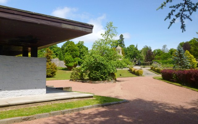
The structure in the left foreground is the park shelter. In the right background is the walled garden (NS2982 : Gate of a walled garden), with a short path (slightly more grey than the pinkish surface that is visible elsewhere) sloping down in front of its gate.
This picture is useful in explaining where Hermitage House stood. The near end of the house was where the shelter now stands. From there, the house extended back almost to the foot of the grey path that slopes down from the gate of the walled garden.
This picture is useful in explaining where Hermitage House stood. The near end of the house was where the shelter now stands. From there, the house extended back almost to the foot of the grey path that slopes down from the gate of the walled garden.
Hermitage Park, Helensburgh
This area was formerly the estate of Hermitage House; the house itself was demolished in 1963. The estate's walled garden still exists, and contains the town's war memorial ( Link ). The ruins of Malig Mill (the mill pre-dates the town of Helensburgh itself) are also located within the park, on the course of the Milligs Burn: Link
War Memorial in Hermitage Park
The memorial, designed by A.N.Paterson, stands in a walled garden, and was built in 1922. Its listed building report Link
(at Historic Environment Scotland) provides further details.
 Map © Crown Copyright")
TIP: Click the map for more Large scale mapping
- Grid Square
- NS2982, 538 images (more nearby 🔍)
- Photographer
- Lairich Rig (more nearby)
- Date Taken
- Wednesday, 26 June, 2013 (more nearby)
- Submitted
- Tuesday, 16 July, 2013
- Subject Location
-
OSGB36:
 NS 2997 8277 [10m precision]
WGS84: 56:0.4574N 4:43.7200W - Camera Location
-
OSGB36: NS 2995 8275
- View Direction
- Northeast (about 45 degrees)