NT1279 : Forth Road Bridge
taken 11 years ago, near to North Queensferry, Fife, Scotland
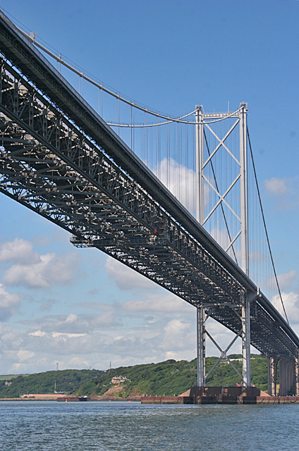
The bridge, opened in 1964, spans the Firth of Forth; connecting the capital city Edinburgh, at South Queensferry, to Fife, at North Queensferry. The bridge replaced a centuries-old ferry service to carry vehicular traffic, cyclists, and pedestrians across the Forth.
When opened, on 4 September 1964 by Her Majesty Queen Elizabeth II, the Forth Road Bridge was the largest suspension bridge in Europe, and, together with the approach viaducts is over 1½ miles long. The bridge has a spectacular central span of over 3300 ft. between its two main towers. The side spans, which carry the deck to the side towers, are each 1340 ft. long and are flanked by approach viaducts.
On 3 April 2001 the Forth Road Bridge was listed as a category 'A' building.
The Forth Bridges Visitor Centre Trust charity (from where much of the above information was gathered) was wound up in April 2012 Link.
Other useful links are:
Forth Bridges Visitor Information Link
Wikipedia entry Link
 Map © Crown Copyright")
- Grid Square
- NT1279, 242 images (more nearby 🔍)
- Photographer
- Anne Burgess (more nearby)
- Date Taken
- Thursday, 18 July, 2013 (more nearby)
- Submitted
- Thursday, 18 July, 2013
- Subject Location
-
OSGB36:
 NT 1255 7995 [10m precision]
WGS84: 56:0.2692N 3:24.2351W - Camera Location
-
OSGB36: NT 1257 7980
- View Direction
- NORTH (about 0 degrees)