NT1380 : The Forth Bridge - northern span
taken 11 years ago, near to North Queensferry, Fife, Scotland
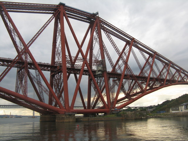
The 1½ mile Forth Bridge was the worlds first major steel bridge. It was begun in 1883 and formally completed on 4 March 1890 when HRH Edward Prince of Wales tapped into place a golden rivet.
It is often incorrectly called the Forth Rail Bridge or Forth Railway Bridge to distinguish it from the nearby Forth Road Bridge which was opened in 1964. The rail bridge connects Edinburgh with Fife, and acts as a major artery connecting the north-east and south-east of the country. The bridge is a category A listed building (LB9977 LinkHistoric Environment Scotland).
Painting the Forth Bridge became a metaphor for a never-ending task, because a team of painters took three years to paint it all, by which time the first bits they had done needed to be re-done, so they started all over again. More advanced and longer-lasting paints now make this unnecessary.
Alfred Hitchcock's 1935 film The 39 Steps includes a scene on the bridge and it is featured even more prominently in the 1959 remake of the same film, although there is no reference to the bridge in the original novel by John Buchan upon which the films are based.
Link
Link
 Map © Crown Copyright")
- Grid Square
- NT1380, 349 images (more nearby 🔍)
- Photographer
- M J Richardson (more nearby)
- Date Taken
- Wednesday, 7 August, 2013 (more nearby)
- Submitted
- Thursday, 8 August, 2013
- Subject Location
-
OSGB36:
 NT 1335 8013 [10m precision]
WGS84: 56:0.3749N 3:23.4691W - Camera Location
-
OSGB36: NT 1346 8004
- View Direction
- Northwest (about 315 degrees)