2013
SP5106 : Merton College Vicinity, Oxford
taken 11 years ago, near to Oxford, Oxfordshire, England
This is 1 of 20 images, with title starting with Merton College in this square
Merton College Vicinity, Oxford
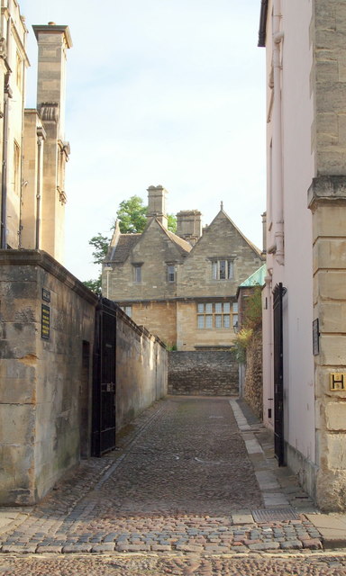
This is the southern entrance/exit Logic Lane, off the similarly-cobbled Merton Street. It seems that Logic Lane was formerly known as Horseman Lane (a.k.a. Horsemull Lane) in the C13th and C14th because of the existence of a nearby horse-powered mill and that the name Logic Lane camre into use by the C16 or C17th, due to the proximity of a school for logicians at the northern end of the lane. This public bridleway leads to/from High Street and is overlooked on either side by parts of University College. There is no access at night due to the existence of locked gates at each end. It appears to be used mainly used by pedestrians, although vehicular access seems possible.
 Map © Crown Copyright")
TIP: Click the map for more Large scale mapping
- Grid Square
- SP5106, 3721 images (more nearby 🔍)
- Photographer
- David Hallam-Jones (more nearby)
- Date Taken
- Saturday, 27 July, 2013 (more nearby)
- Submitted
- Tuesday, 20 August, 2013
- Subject Location
-
OSGB36:
 SP 5178 0613 [10m precision]
WGS84: 51:45.0887N 1:15.0786W - Camera Location
-
OSGB36: SP 5178 0613
- View Direction
- NORTH (about 0 degrees)