2013
NJ0459 : Sueno's Stone
taken 11 years ago, near to Springfield, Moray, Scotland
This is 1 of 11 images, with title Sueno's Stone in this square
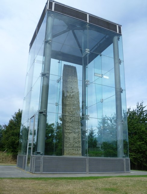
Sueno's Stone
Scotland's tallest Pictish slab, rising to a height of 23 feet, is an awesome sight. The level of protection accorded it is impressive but tends to mar the visual effect.
Information provided at the site lists the various theories concerning its significance and date. Since it features a great battle scene on its rear face, one suggestion is that it marks the site of a defeat of the Picts at the hands of the Scots led by Kenneth macAlpin in the mid-9th century. Another possibility is that it depicts a conflict between Picto-Scottish warriors and Norse marauders in the late 9th or early 10th centuries. A third possibility is that it refers to a clash of arms at Forres in 966 AD when the Scottish king Dubh was killed by men of Moray. After the battle the king's corpse lay beneath the bridge at Kinloss a short distance away, which might explain one of the carvings which looks like a bridge. The name 'Sueno's Stone' is an 18thC invention.
This is reputedly the spot where Macbeth met the witches. When Shakespeare's Banquho asks, "How far is't call'd to Forres?", it's odd that no-one tells him, "It's just round the corner".
 Map © Crown Copyright")
TIP: Click the map for more Large scale mapping
- Grid Square
- NJ0459, 116 images (more nearby 🔍)
- Photographer
- kim traynor (more nearby)
- Date Taken
- Wednesday, 4 September, 2013 (more nearby)
- Submitted
- Saturday, 5 October, 2013
- Subject Location
-
OSGB36:
 NJ 0465 5953 [10m precision]
WGS84: 57:36.9381N 3:35.8650W - Camera Location
-
OSGB36: NJ 0466 5952
- View Direction
- Northwest (about 315 degrees)