2013
SN4020 : Ordnance Survey Benchmark and Bolt - Carmarthen, St. David's Church
taken 11 years ago, near to Carmarthen/Caerfyrddin, Carmarthenshire/Sir Gaerfyrddin, Wales
This is 1 of 2 images, with title Ordnance Survey Benchmark and Bolt - Carmarthen, St. David's Church in this square
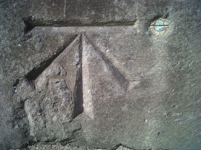
Ordnance Survey Benchmark and Bolt - Carmarthen, St. David's Church
Ordnance Survey Benchmark (OSBM) used for levelling height above Ordnance Datum (OD).
Height (1954): 26.9023m OD (Newlyn). Mark verified by the Ordnance Survey in 1976. Description: PA BOLT W SIDE ENT ST DAVIDS CH S FACE. 0.6m above ground. 1st Order BM.
The bolt was used on the Llanstephan to Dolfor Toll-house line of the First Primary Levelling of England & Wales in 1856-1857. It was levelled with a height of 88.597' above OD (Liverpool). Description: 18. Bolt in South side of St. David's Church Tower, Caermarthen ; 2.36 ft. above surface. Page 576 of the abstract: Link
The bolt was included on the Carmarthen to Haverford West line (G075) of the Third Geodetic Levelling of England & Wales in 1954. Abstract G 64: Link [OS 54/753]
Context: SN4020 : Ordnance Survey Benchmark and Bolt - Carmarthen, St. David's Church
Height (1954): 26.9023m OD (Newlyn). Mark verified by the Ordnance Survey in 1976. Description: PA BOLT W SIDE ENT ST DAVIDS CH S FACE. 0.6m above ground. 1st Order BM.
The bolt was used on the Llanstephan to Dolfor Toll-house line of the First Primary Levelling of England & Wales in 1856-1857. It was levelled with a height of 88.597' above OD (Liverpool). Description: 18. Bolt in South side of St. David's Church Tower, Caermarthen ; 2.36 ft. above surface. Page 576 of the abstract: Link
The bolt was included on the Carmarthen to Haverford West line (G075) of the Third Geodetic Levelling of England & Wales in 1954. Abstract G 64: Link
Context: SN4020 : Ordnance Survey Benchmark and Bolt - Carmarthen, St. David's Church
 Map © Crown Copyright")
TIP: Click the map for more Large scale mapping
- Grid Square
- SN4020, 183 images (more nearby 🔍)
- Photographer
- N Scott (more nearby)
- Date Taken
- Tuesday, 8 October, 2013 (more nearby)
- Submitted
- Friday, 11 October, 2013
- Subject Location
-
OSGB36:
 SN 4055 2009 [10m precision]
WGS84: 51:51.3934N 4:19.0036W - Camera Location
-
OSGB36: SN 4055 2009
- View Direction
- NORTH (about 0 degrees)