NT2072 : Fire damaged fitness studio and community centre
taken 11 years ago, near to Corstorphine, Edinburgh, Scotland
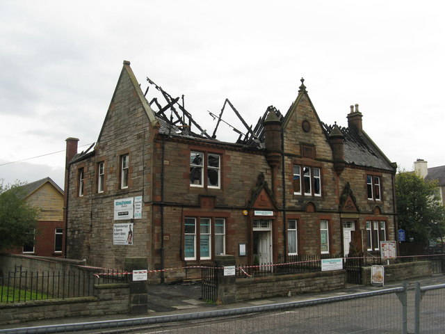
Discovered while avoiding traffic on the main road in Corstorphine. The fire is thought to have started in a fitness centre at about 10.00 and the local Youth and Community Centre was well alight just after midday. Children were evacuated, but nobody was injured. Many fire appliances were in attendance, and a lot of local roads closed as a result. My only view point was from a road to the south, with view restricted by a wall and hedge. Link
. Link
In early 2017 rebuilding of the eastern end, and conversion into two residential apartments, was started, and a fund-raising appeal to restore the community centre part of the building was ongoing.
By June 2022 a newspaper reported that attempts to get funding from the Lottery and the Council to restore the building had failed.The site was put up for sale, and was reported to be under offer. I could not find details, but in January 2023 it was still under offer.
 Map © Crown Copyright")
- Grid Square
- NT2072, 177 images (more nearby 🔍)
- Photographer
- M J Richardson (more nearby)
- Date Taken
- Wednesday, 16 October, 2013 (more nearby)
- Submitted
- Wednesday, 16 October, 2013
- Subject Location
-
OSGB36:
 NT 2005 7269 [10m precision]
WGS84: 55:56.4350N 3:16.8916W - Camera Location
-
OSGB36: NT 2005 7271
- View Direction
- SOUTH (about 180 degrees)