2013
TQ9174 : Sheerness: The former Royal Fountain Hotel
taken 10 years ago, near to Sheerness, Kent, England
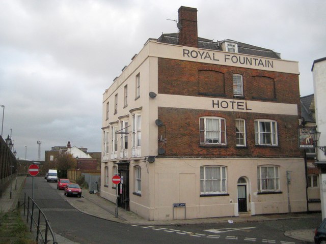
Sheerness: The former Royal Fountain Hotel
The Royal Fountain Hotel in the Blue Town area of Sheerness dates from 1807, according to the heritage plaque on the dockyard wall opposite, and was the superior hostelry for dockyard, navy and army officers and wealthy visitors to the town. As demand for its services dwindled it finally closed as a hotel in 1982. It is a Grade II Listed building and the English Heritage website describes it thus:-
"An 18th century hotel with Nelson associations. Corner building. The West Street elevation (on the left in the photo) is of 3 storeys and attics faced with rough plaster and paint. 4 dormers. Painted plinth. 4 windows to each floor. The 1st floor has bow windows and panelled sash boxes and moulded head. 3 cambered dashes to ground floor. Front entrance has moulded pilasters and architrave, panelled reveals and Vitruvian scroll frieze. Grooved surround to doorway. The south elevation (facing in the photo) is of brown brick. 3 cambered sashes. Painted plinth."
If Nelson died in 1805 and the hotel was built in 1807 what are the Nelson associations being referred to? (The photographer thinks that "dashes" in the description is a typo and should read "sashes".)
 Map © Crown Copyright")
TIP: Click the map for more Large scale mapping
- Grid Square
- TQ9174, 138 images (more nearby 🔍)
- Photographer
- Nigel Cox (more nearby)
- Date Taken
- Sunday, 24 November, 2013 (more nearby)
- Submitted
- Monday, 2 December, 2013
- Subject Location
-
OSGB36:
 TQ 9110 7493 [10m precision]
WGS84: 51:26.4672N 0:44.8991E - Camera Location
-
OSGB36: TQ 9110 7491
- View Direction
- NORTH (about 0 degrees)