2013
TQ3283 : Regent's Canal near City Road Basin
taken 10 years ago, near to Shoreditch, Islington, England
Regent's Canal near City Road Basin
Construction of a national canal network began in the late 18th century, but initially the canal from the Midlands ended at Paddington, and there was no link to eastern London until the Regent's Canal was built. It was the brainchild of engineer Thomas Homer who, in 1812, presented a plan to the Grand Junction Company (which owned the canal from London to Birmingham) for the creation of a waterway from Limehouse to Paddington. To begin with the project progressed quickly, largely passing through what was then agricultural land, but it was soon hampered by financial problems. Stubborn and greedy landowners asked inflated prices for property along the preferred route, and, to make matters worse, Thomas Homer disappeared in 1815 taking the company's funds with him. New legislation passed in 1817 enabled the work to be completed by 1820 using funds borrowed from the Treasury.
The canals were initially a success, particularly for transporting coal, building materials and other bulky loads, but the rise of the railways not long after the canals were built substantially reduced their importance. Now they are primarily a leisure facility. What was then the Central Electricity Generating Board laid cables under some of the towpaths in the 1970s and made them suitable for pedestrians again as seen here.
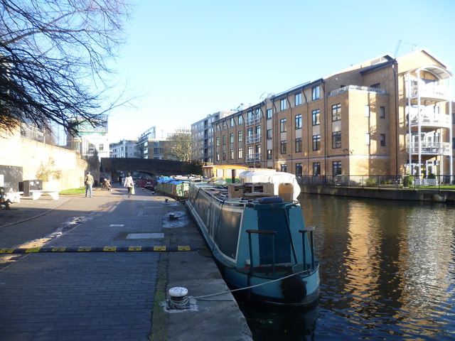
This is the Regent's Canal where it passes City Road Basin. This is out of the picture to the right. The bridge ahead carries Wharf Road over the canal.
The canals were initially a success, particularly for transporting coal, building materials and other bulky loads, but the rise of the railways not long after the canals were built substantially reduced their importance. Now they are primarily a leisure facility. What was then the Central Electricity Generating Board laid cables under some of the towpaths in the 1970s and made them suitable for pedestrians again as seen here.
This is the Regent's Canal where it passes City Road Basin. This is out of the picture to the right. The bridge ahead carries Wharf Road over the canal.
 Map © Crown Copyright")
TIP: Click the map for more Large scale mapping
- Grid Square
- TQ3283, 611 images (more nearby 🔍)
- Photographer
- Marathon (more nearby)
- Date Taken
- Thursday, 19 December, 2013 (more nearby)
- Submitted
- Saturday, 21 December, 2013
- Subject Location
-
OSGB36:
 TQ 3206 8325 [10m precision]
WGS84: 51:31.9632N 0:5.8485W - Camera Location
-
OSGB36: TQ 3201 8325
- View Direction
- EAST (about 90 degrees)