2013
TQ3377 : Christmas Day on Chandler Way, North Peckham
taken 10 years ago, near to Camberwell, Southwark, England
Christmas Day on Chandler Way, North Peckham
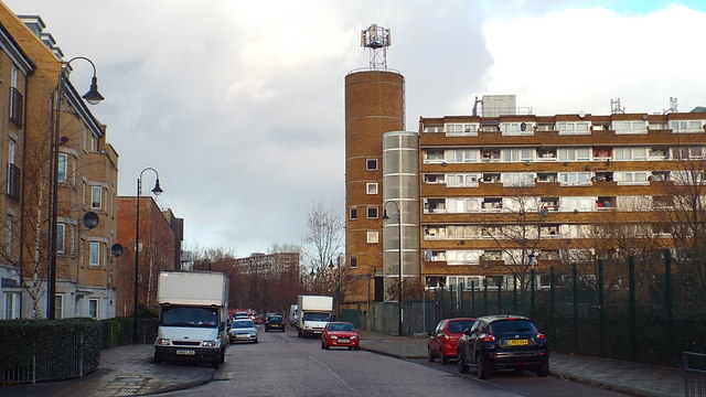
A view taken just after midday on Christmas Day 2013 along Chandler Way.
The housing to the left of the road dates from the early 21st Century, when the area was extensively regenerated. The block to the right of the image is older, it is part of Gloucester Grove Estate built in the early 1970s. Straight ahead in the distance is another housing block, part of the Aylesbury Estate which was developed in the 1960s and 1970s.
The housing to the left of the road dates from the early 21st Century, when the area was extensively regenerated. The block to the right of the image is older, it is part of Gloucester Grove Estate built in the early 1970s. Straight ahead in the distance is another housing block, part of the Aylesbury Estate which was developed in the 1960s and 1970s.
North Peckham
The North Peckham area has seen major changes in recent decades.
In the early 1970s, a huge council housing estate was built here. High-level walkways connected the blocks of flats. The estate replaced traditional streets and housing that had been built in Victorian times.
Over time, the estate gained a reputation for crime and social problems.
Urban regeneration came at the start of the 21st Century. Part of the estate was demolished, replaced by new streets flanked by a mix of privately-owned and social housing. In other parts of the estate, where the 1970s-built flats still stand, the high-level walkways have been removed and entryphone systems installed, to improve security and to reduce the risk of crime.
 Map © Crown Copyright")
TIP: Click the map for more Large scale mapping
- Grid Square
- TQ3377, 332 images (more nearby 🔍)
- Photographer
- Malc McDonald (more nearby)
- Date Taken
- Wednesday, 25 December, 2013 (more nearby)
- Submitted
- Wednesday, 25 December, 2013
- Subject Location
-
OSGB36:
 TQ 3342 7747 [10m precision]
WGS84: 51:28.8275N 0:4.8038W - Camera Location
-
OSGB36: TQ 3342 7746
- View Direction
- North-northwest (about 337 degrees)