SK6325 : Church of St Mary and All Saints, Willoughby
taken 10 years ago, near to Willoughby-on-The-Wolds, Nottinghamshire, England
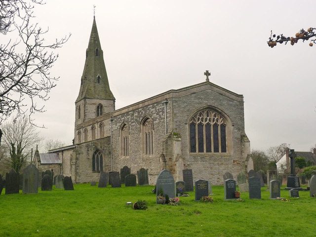
Grade I listed.
Willoughby on the Wolds dates back to Roman times, being close to the Fosse Way. It was known as Vernometum. Willoughby is also mentioned in the Domesday book.
The present church dates from the 13th century onwards, although there was an earlier church. The chapel was repaired in 1781, and the church was enlarged in 1829 and chancel rebuilt 1891. The porch was built in 1908 and the chapel again restored in 1984.
The church has a tower with spire, nave, aisles, north chantry Chapel, south porch and chancel.
The tower dates from the 13th century and is of two stages with an early 14th century broach spire with two tiers of four lucarnes. There are six bells.
The nave has a 15th century clerestory with four windows each of three lights.
The nave has a four Bay early 13th century arcade with circular columns some of the capitals have foliate carving. The chancel arch and rood screen are 19th century. There is a two Bay arcade to the north chapel, the west wall of the chapel has 13th century blind arcading. This chapel contains tombs to the Willoughby family.
The nave roof is 15th century with moulded, carved beams with decorative bosses. The south aisle has the remains of a wall painting.
The font is 14th century, octagonal. Most of the other fittings are 19th century.
The church fell into a poor state of repair in the 18th and 19th centuries. The chancel was rebuilt in 1890 and a new east window was installed.
The organ is a two manual instrument by Wragg and son of Nottingham. It was originally at Bottesford.
Listed buildings and structures are officially designated as being of special architectural, historical or cultural significance. There are over half a million listed structures in the United Kingdom, covered by around 375,000 listings.
Listed status is more commonly associated with buildings or groups of buildings, however it can cover many other structures, including bridges, headstones, steps, ponds, monuments, walls, phone boxes, wrecks, parks, and heritage sites, and in more recent times a road crossing (Abbey Road) and graffiti art (Banksy 'Spy-booth') have been included.
In England and Wales there are three main listing designations;
Grade I (2.5%) - exceptional interest, sometimes considered to be internationally important.
Grade II* (5.5%) - particularly important buildings of more than special interest.
Grade II (92%) - nationally important and of special interest.
There are also locally listed structures (at the discretion of local authorities) using A, B and C designations.
In Scotland three classifications are also used but the criteria are different. There are around 47,500 Listed buildings.
Category A (8%)- generally equivalent to Grade I and II* in England and Wales
Category B (51%)- this appears generally to cover the ground of Grade II, recognising national importance.
Category C (41%)- buildings of local importance, probably with some overlap with English Grade II.
In Northern Ireland the criteria are similar to Scotland, but the classifications are:
Grade A (2.3%)
Grade B+ (4.7%)
Grade B (93%)
Read more at Wikipedia Link
 Map © Crown Copyright")
- Grid Square
- SK6325, 135 images (more nearby 🔍)
- Photographer
- Alan Murray-Rust (more nearby)
- Date Taken
- Friday, 24 January, 2014 (more nearby)
- Submitted
- Monday, 27 January, 2014
- Subject Location
-
OSGB36:
 SK 6339 2541 [10m precision]
WGS84: 52:49.3503N 1:3.6449W - Camera Location
-
OSGB36: SK 6342 2540
- View Direction
- West-northwest (about 292 degrees)