2014
SP7006 : County boundary marker
taken 10 years ago, near to Thame, Oxfordshire, England
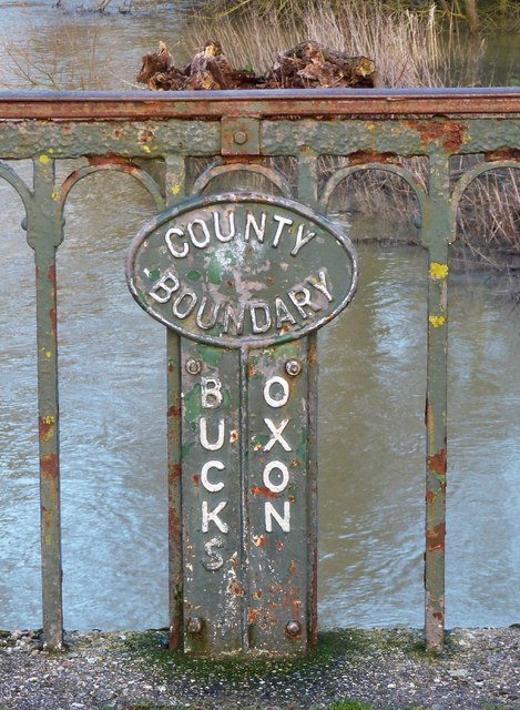
County boundary marker
This marker is in the middle of SP7006 : Thame Bridge on the old Thame Road on the outskirts of the town of Thame, named after the river.
The River Thame forms the boundary between Buckinghamshire and Oxfordshire for a few miles between a point just north of the town and a mile or so to the west of Ickford.
The River Thame forms the boundary between Buckinghamshire and Oxfordshire for a few miles between a point just north of the town and a mile or so to the west of Ickford.
River Thame
The River Thame (pronounced "Tame") rises in the northern Chilterns as a combination of several streams to the north of Aylesbury. It meanders for about 40 miles through Buckinghamshire and Oxfordshire, past the town named after it until it meets The Thames at Dorchester on Thames (Oxon). At most times it is a fairly insubstantial river, especially in its more northerly reaches, but after heavy rains it can become far bigger - such as after the prolonged series of downpours experienced from Dec 2013 to Feb 2014; then it bursts its banks and floods the neighbouring land - mostly farmland - in its wide shallow valley.
 Map © Crown Copyright")
TIP: Click the map for more Large scale mapping
- Grid Square
- SP7006, 327 images (more nearby 🔍)
- Photographer
- Rob Farrow (more nearby)
- Date Taken
- Saturday, 15 February, 2014 (more nearby)
- Submitted
- Tuesday, 18 February, 2014
- Subject Location
-
OSGB36:
 SP 7035 0650 [10m precision]
WGS84: 51:45.1671N 0:58.9361W - Camera Location
-
OSGB36: SP 7035 0650
- View Direction
- East-northeast (about 67 degrees)