2005
NS5956 : The Peel
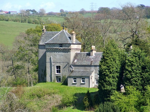
taken 19 years ago, near to Thorntonhall, South Lanarkshire, Scotland
This is 1 of 2 images, with title The Peel in this square
The Peel
The view is from the pavement beside East Kilbride Road (compare NS5856 : Welcome to South Lanarkshire, taken nearby). The core of this cluster of buildings is a house that is thought to date from the sixteenth century; as the photo shows, a square tower is prominent in the view from this angle.
"The History of Rutherglen and East-Kilbride" (1793), by the minister David Ure, contains a passage about the Peel; it is reproduced below in its entirety, with spellings as they appear in the book:
"The Piel, which stands on the south bank of Kittoch, at the north-west boundary of the parish, is justly entitled to a place among the ancient buildings in Kilbride. The old castle, few vestiges of which now remain, stood about a quarter of a mile to the west of the present building; but when, and by whom it was built, is not known. The most considerable part of the present edifice was built near two centuries ago. Since that time it has received some additions which contribute greatly to the beauty of the place. Having experienced a great number of masters, it is now in the possession of Andrew Houston, Esq; of Jordon-hill. The house, though not at present inhabited, is in tolerable repair; and might, at a small expence, be rendered commodious. The Compass, containing the 32 points, is painted on the ceiling of the uppermost apartment: the index, which is fixed to an iron rod that goes through the roof, is directed by the wind in whatever point it blows."
Note that an iron rod can still be seen emerging from the tower's apex.
For a wider view (for context), taken on the same occasion from almost the same spot, see NS5956 : The Peel, which also identifies the distant buildings at the upper left corner of the present picture. Some other contributors' photographs are also linked from there.
 Map © Crown Copyright")
TIP: Click the map for more Large scale mapping
- Grid Square
- NS5956, 15 images (more nearby 🔍)
- Photographer
- Lairich Rig (more nearby)
- Date Taken
- Friday, 29 April, 2005 (more nearby)
- Submitted
- Saturday, 22 March, 2014
- Subject Location
-
OSGB36:
 NS 5929 5609 [10m precision]
WGS84: 55:46.6559N 4:14.6987W - Camera Location
-
OSGB36: NS 5903 5605
- View Direction
- EAST (about 90 degrees)