2014
NS3679 : Carman Quarry
taken 10 years ago, near to Renton, West Dunbartonshire, Scotland
This is 1 of 3 images, with title Carman Quarry in this square
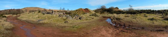
Carman Quarry
See NS3678 : Carman Quarry for the main description. Click on the end-note title for related pictures.
The former Fairy Knowe Quarry :: NS3779
Red sandstone was quarried here. The site was formerly a small hill called Fairy Knowe, but it became a quarry at the end of the nineteenth century; later maps call it Carman Quarry. It has long been disused. See Link
for an annotated satellite view putting this site in its geological context. See Link and Link (in a Geograph article) for more on the quarry, the Fairy Knowe, and old traditions about this site and Havoc Hole.
This image has a WideAngle Panorama attached. Open Viewer
 Map © Crown Copyright")
TIP: Click the map for more Large scale mapping
- Grid Square
- NS3679, 44 images (more nearby 🔍)
- Photographer
- Lairich Rig (more nearby)
- Date Taken
- Wednesday, 12 March, 2014 (more nearby)
- Submitted
- Tuesday, 15 April, 2014
- Subject Location
-
OSGB36:
 NS 3690 7901 [10m precision]
WGS84: 55:58.5770N 4:36.9222W - Camera Location
-
OSGB36: NS 3689 7900
- View Direction
- Northeast (about 45 degrees)