SD7807 : Radcliffe Park and Ride Construction - April 2014
taken 10 years ago, near to Radcliffe, Bury, England
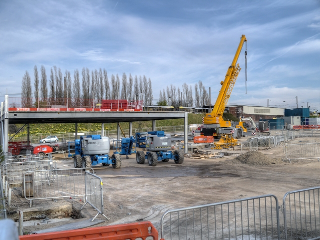
Work to increase the capacity of the existing Park and Ride facility at the Radcliffe Metrolink stop began in early March 2014. The building work is aimed at benefitting Metrolink customers by increasing the number of parking spaces from 250 to approximately 364 by the construction of a decked car park. Additionally, it is hoped that it will help to reduce congestion on the roads near the station and cut down on the amount of on-street parking by commuters, particularly in front of the houses on Spring Lane and Church Street. During the construction work, the capacity of the car park was significantly reduced (to approx. 70 spaces).
During the planning consultations, concern was expressed that the cars parked on the first floor level would be at the same level as neighbouring houses, so TfGM plans to use landscaping, including shrubs, to shield the car park from view. It was expected that the work would take about five months to complete.
The park and ride facility in Radcliffe was first brought into operation when the Bury line opened in 1992. Metrolink passengers may park free-of-charge during the times that the service is operating.
LinkBury Times
SD7807 : The car park at Radcliffe Metrolink station, taken in 2012, shows the car park before expansion.
 Map © Crown Copyright")
- Grid Square
- SD7807, 934 images (more nearby 🔍)
- Photographer
- David Dixon (more nearby)
- Date Taken
- Wednesday, 16 April, 2014 (more nearby)
- Submitted
- Thursday, 17 April, 2014
- Subject Location
-
OSGB36:
 SD 7874 0742 [10m precision]
WGS84: 53:33.7776N 2:19.3467W - Camera Location
-
OSGB36: SD 7871 0742
- View Direction
- EAST (about 90 degrees)