2013
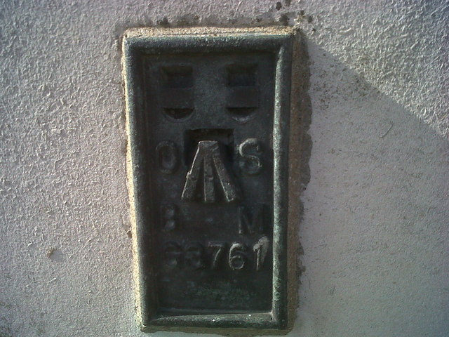
SN4119 : OSBM Flush Bracket G3761 - Carmarthen, County Hall
taken 11 years ago, near to Carmarthen/Caerfyrddin, Carmarthenshire/Sir Gaerfyrddin, Wales
This is 1 of 4 images, with title OSBM Flush Bracket G3761 - Carmarthen, County Hall in this square
OSBM Flush Bracket G3761 - Carmarthen, County Hall
Ordnance Survey Benchmark (OSBM) used for levelling height above Ordnance Datum (OD).
Height (1956): 21.8201m OD (Newlyn). Mark verified by the Ordnance Survey in 1976. Description: FL BR G3761 COUNTY HALL E FACE 10.0M NE ANG. 0.4m above ground. 1st Order BM.
The bracket was used on the Bishopston to Carmarthen line (G134) of the Third Geodetic Levelling of England & Wales in 1956. Description: E face, County Hall, Carmarthen. Abstract G 74: Link [OS 54/763]
Context: SN4119 : OSBM Flush Bracket G3761 - Carmarthen, County Hall
Height (1956): 21.8201m OD (Newlyn). Mark verified by the Ordnance Survey in 1976. Description: FL BR G3761 COUNTY HALL E FACE 10.0M NE ANG. 0.4m above ground. 1st Order BM.
The bracket was used on the Bishopston to Carmarthen line (G134) of the Third Geodetic Levelling of England & Wales in 1956. Description: E face, County Hall, Carmarthen. Abstract G 74: Link
Context: SN4119 : OSBM Flush Bracket G3761 - Carmarthen, County Hall
 Map © Crown Copyright")
TIP: Click the map for more Large scale mapping
- Grid Square
- SN4119, 387 images (more nearby 🔍)
- Photographer
- N Scott (more nearby)
- Date Taken
- Tuesday, 8 October, 2013 (more nearby)
- Submitted
- Friday, 18 April, 2014
- Subject Location
-
OSGB36:
 SN 4136 1996 [10m precision]
WGS84: 51:51.3372N 4:18.2949W - Camera Location
-
OSGB36: SN 4136 1996
- View Direction
- WEST (about 270 degrees)