TQ3978 : Enderby House, at risk
taken 10 years ago, near to Greenwich, England
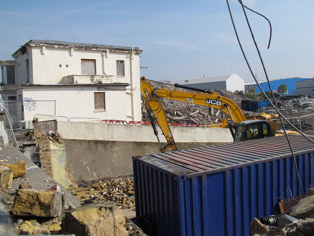
The peninsula is formed by a meander of the River Thames north-east of Greenwich, which along with the Isle of Dogs to the west, forms the distinctive outline familiar from the opening credits of the TV series "Eastenders". Until the 18th century it was marshland, thereafter gradually drained and industrialised, and in the late 19th century dominated by the South Metropolitan Gasworks. After becoming largely derelict in the later 20th century, the east side of the peninsula was remediated and redeveloped from the 1990s onwards, the focus being the Millennium Dome (later O2 Arena). The west side remained industrial for longer although by 2010 the remaining industries there were starting to close and be replaced by residential developments and an ocean liner terminal.
For a detailed history of the industrial sites on Greenwich Peninsula, see the book "Greenwich Marsh - the 300 years before the Dome", Mills, Mary - self-published 1999. ISBN 0 9535245 0 7
For a photographic record of the west side of the peninsula before recent demolitions, see Link
 Map © Crown Copyright")
- Grid Square
- TQ3978, 436 images (more nearby 🔍)
- Photographer
- Stephen Craven (more nearby)
- Date Taken
- Monday, 21 April, 2014 (more nearby)
- Submitted
- Tuesday, 22 April, 2014
- Subject Location
-
OSGB36:
 TQ 3914 7876 [10m precision]
WGS84: 51:29.4404N 0:0.1658E - Camera Location
-
OSGB36: TQ 3913 7874
- View Direction
- North-northeast (about 22 degrees)