2014
NN3213 : Pulpit Rock Improvement Works, Loch Lomond Shore
taken 10 years ago, near to Ardlui, Argyll And Bute, Scotland
Pulpit Rock Improvement Works, Loch Lomond Shore
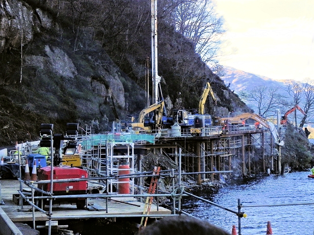
The A82 at Pulpit Rock has offered a significant engineering challenge for decades. The road narrows at one stretch to less than 7.3m wide, resulting in road users delayed at traffic signals which reduce traffic to one-lane causing a traffic congestion black spot on the banks of Loch Lomond.
The improvement work at Pulpit Rock will see the removal of the traffic signals, which have been in place for over 30 years, and the stretch of road, widened to provide a two-way carriageway. (Link A virtual Model of the completed project YouTube)
Work began in May 2013 and it is expected that it will take approximately 12 months to complete.
Link (Archive Link ) (Transport Scotland)
Link BBC Scotland
The improvement work at Pulpit Rock will see the removal of the traffic signals, which have been in place for over 30 years, and the stretch of road, widened to provide a two-way carriageway. (Link
Work began in May 2013 and it is expected that it will take approximately 12 months to complete.
Link
Link
The A82
The A82 runs from Glasgow to Fort William and Inverness, passing along the shores of Loch Lomond and Loch Ness and in the shadow of Ben Nevis along the way. The majority of the route is a trunk road and hence managed by Transport Scotland, who view the road as a vitally important link through the Scottish Highlands and beyond.
At 167 miles, the road is the second longest A-road in Scotland (after the A9) and along its route uses pieces of road first built in the 1750s.
 Map © Crown Copyright")
TIP: Click the map for more Large scale mapping
- Grid Square
- NN3213, 45 images (more nearby 🔍)
- Photographer
- David Dixon (more nearby)
- Date Taken
- Monday, 24 March, 2014 (more nearby)
- Submitted
- Sunday, 4 May, 2014
- Subject Location
-
OSGB36:
 NN 3268 1363 [10m precision]
WGS84: 56:17.1318N 4:42.2791W - Camera Location
-
OSGB36: NN 3270 1357
- View Direction
- NORTH (about 0 degrees)