2014
TQ0950 : Archway, Briary Hill, Dick Focks Common
taken 10 years ago, near to West Horsley, Surrey, England
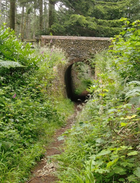
Archway, Briary Hill, Dick Focks Common
This shot records my first glimpse of this unlikely structure. I knew nothing of its existence when I set off along a Forestry Commission track, starting at an entrance marked 'Dick Focks Common'. For a moment I thought I'd found a two-dimensional folly (lost here in the woods?) or something left over from location filming.
I scrambled up the bank only to find that if there had ever been a track going over the bridge it was now completely overgrown. The other puzzle was the narrow path that went underneath, approaching in a long narrow trench. One possibility I considered was that there may have been a narrow-gauge railway here - like one I'd seen near Hascombe: Link
Had I known more of the history of the area I'd have recognised this structure as one of the so-called Lovelace bridges - devised by William King, first Lord Lovelace, as part of a system for extracting timber. Ten bridges survive. The narrow passage beneath the bridge is in fact a bridleway - wagons loaded with logs went over the top.
The system has been documented for Geograph by Colin Smith, who also describes a trail put together by the Horsley Countryside Preservation Society: Link Plaques have been attached to a number of bridges, though not to this one (Briary Hill West) and I have to say that suits me, as I prefer to puzzle out the possibilities for myself!
 Map © Crown Copyright")
TIP: Click the map for more Large scale mapping
- Grid Square
- TQ0950, 57 images (more nearby 🔍)
- Photographer
- Stefan Czapski (more nearby)
- Date Taken
- Monday, 30 June, 2014 (more nearby)
- Submitted
- Tuesday, 1 July, 2014
- Subject Location
-
OSGB36:
 TQ 0985 5081 [10m precision]
WGS84: 51:14.7537N 0:25.6536W - Camera Location
-
OSGB36: TQ 0986 5081
- View Direction
- West-northwest (about 292 degrees)