2014
SU1578 : Pillbox (2) Beranburh field, Wroughton, Swindon
taken 10 years ago, near to Overtown, Swindon, England
Pillbox (2) Beranburh field, Wroughton, Swindon
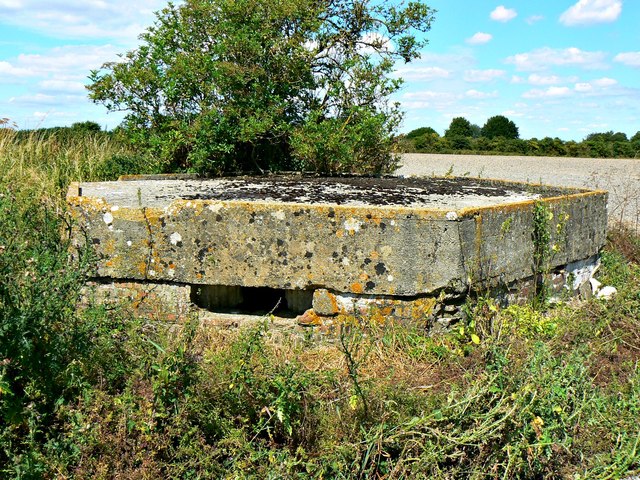
This Type FW3/22 pillbox is one of several dotted around the former RAF Wroughton WWII airfield as part of the ground defences of the facility. From the Archaeology Data Services website:
"A regular hexagon pillbox, with 6 embrasures. It is well constructed of concrete with brick shuttering and external cement cladding (now partially eroded). The ground is level with the bottom of the embrasures, and the roof has a lip around it with drainage holes. In the centre of the roof is a 2.5ft deep square hole [possibly an anti-aircraft or antenna mount?]. Access is by an offset half doorway protected by semi-sunken exterior blast walls. The main arc of the pillbox is SE to E."
"A regular hexagon pillbox, with 6 embrasures. It is well constructed of concrete with brick shuttering and external cement cladding (now partially eroded). The ground is level with the bottom of the embrasures, and the roof has a lip around it with drainage holes. In the centre of the roof is a 2.5ft deep square hole [possibly an anti-aircraft or antenna mount?]. Access is by an offset half doorway protected by semi-sunken exterior blast walls. The main arc of the pillbox is SE to E."
Pillboxes around RAF Stations
Compiled by Brian Robert Marshall
Numerous pillboxes were installed in Britain during the Second World War, mainly to help defend the country in the event of invasion by Axis forces. These were placed alongside or in the vicinity of lines of communication such as railways, canals and rivers. Others, like those at Wroughton and Yatesbury, had a different although related purpose - to protect the airfields against enemy forces. Thankfully, the German high command decided against invading England in 1940 so these defences were never tested in battle. They remain as mute witnesses to the state of the nation's mind at the time they were constructed.
 Map © Crown Copyright")
TIP: Click the map for more Large scale mapping
- Grid Square
- SU1578, 14 images (more nearby 🔍)
- Photographer
- Brian Robert Marshall (more nearby)
- Date Taken
- Tuesday, 29 July, 2014 (more nearby)
- Submitted
- Wednesday, 30 July, 2014
- Subject Location
-
OSGB36:
 SU 157 788 [100m precision]
WGS84: 51:30.4803N 1:46.4846W - Camera Location
-
OSGB36: SU 157 788
- View Direction
- NORTH (about 0 degrees)