2014
TM1881 : RAF Thorpe Abbotts - 351st Bombardment Squadron plaque
taken 10 years ago, near to Upper Street, Norfolk, England
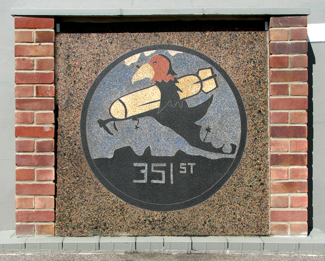
RAF Thorpe Abbotts - 351st Bombardment Squadron plaque
It is made from coloured granite with stainless steel insets and was originally located on Site 1 > Link - the 351st bomb squadron's living area. Ever since most of the buildings on this site were demolished in 1950 the stone was kept in the garden of a private dwelling in the village of Bedingham in Suffolk, until in 2010 the owner offered it to the Memorial Museum. It is believed to have been made by 351st personnel who had stonemasonry skills. It has been set into the wall of the Engine shed > Link which is one of the original buildings remaining on the museum site.
The airfield has long since been returned to agriculture and the farmers make use of the concrete tracks and hardstandings. During WWII the village of Thorpe Abbotts became home to an airbase with the designation 139, Thorpe Abbotts. It was built in 1942 for the RAF by John Laing & Sons Ltd but was handed over to the Americans. The 100th Bombardment Group (Heavy) arrived in June 1943 when construction work was barely finished. The unit bombed airfields, industries, marshalling yards, and missile sites in western Europe and completed a series of attacks against Berlin in March 1944. The 100th Bomb Group Memorial Museum, dedicated to the USAAF's famous 'Bloody Hundredth' Bomb Group of WWII, is housed in the original airfield control tower near Thorpe Abbotts: Link (Archive Link ) . The airfield consisted of 50 hardstandings, three intersecting runways and it had two T-2 hangars which were erected adjacent to the technical site.
See also: Link
The airfield has long since been returned to agriculture and the farmers make use of the concrete tracks and hardstandings. During WWII the village of Thorpe Abbotts became home to an airbase with the designation 139, Thorpe Abbotts. It was built in 1942 for the RAF by John Laing & Sons Ltd but was handed over to the Americans. The 100th Bombardment Group (Heavy) arrived in June 1943 when construction work was barely finished. The unit bombed airfields, industries, marshalling yards, and missile sites in western Europe and completed a series of attacks against Berlin in March 1944. The 100th Bomb Group Memorial Museum, dedicated to the USAAF's famous 'Bloody Hundredth' Bomb Group of WWII, is housed in the original airfield control tower near Thorpe Abbotts: Link
See also: Link
 Map © Crown Copyright")
TIP: Click the map for more Large scale mapping
- Grid Square
- TM1881, 140 images (more nearby 🔍)
- Photographer
- Evelyn Simak (more nearby)
- Date Taken
- Saturday, 9 August, 2014 (more nearby)
- Submitted
- Saturday, 9 August, 2014
- Subject Location
-
OSGB36:
 TM 1869 8133 [10m precision]
WGS84: 52:23.1781N 1:12.7317E - Camera Location
-
OSGB36: TM 1870 8133
- View Direction
- West-northwest (about 292 degrees)