SK7685 : Church of St Peter & St Paul, North Wheatley
taken 10 years ago, near to North Wheatley, Nottinghamshire, England
A simple church consisting of aisleless nave and chancel with 19th century vestry and a west tower. The nave is largely 15th century, as is the tower. The chancel was rebuilt in 1824, and the vestry added at this time. The exterior is generally unexceptional; the large west window in Perpendicular style is a 19th century insertion.
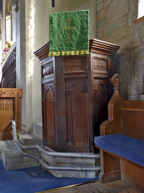
The interior contains several items of note. The font is a simple Norman tub font. Close to the font is an old hand-quern set into the wall, possibly to serve as a stoup. Also the remains of a Roman tombstone found in the churchyard in 1928. Ten of the bench ends are original early 15th century (attached to modern benches) with traceried panels and the remainder are 20th century copies. There is a small ogee-headed aumbry in the south wall of the nave. The pulpit is late Elizabethan in style, dating from 1604. The ladder-staircase up to the ringing chamber consists of rough-hewn oak steps attached to a pair of oak beams and may be medieval in original - certainly pre-19th century.
The south door is an unusual triangular arch without curves of early 16th century origin.
The church is Listed Grade II*. For more information see Link
 Map © Crown Copyright")
- Grid Square
- SK7685, 101 images (more nearby 🔍)
- Photographer
- Alan Murray-Rust (more nearby)
- Date Taken
- Sunday, 28 September, 2014 (more nearby)
- Submitted
- Saturday, 4 October, 2014
- Subject Location
-
OSGB36:
 SK 7620 8586 [10m precision]
WGS84: 53:21.8477N 0:51.3825W - Camera Location
-
OSGB36: SK 7620 8586
- View Direction
- Southeast (about 135 degrees)